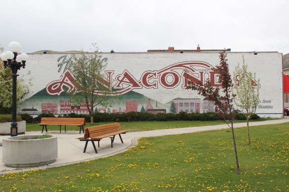
 The public landscape of Anaconda has already been touched on in this blog–places like Washoe Park, the cemeteries, or Mitchell Stadium for instance. Now I want to go a bit deeper and look at public buildings, both government and education in this smelter city.
 Let’s begin with the only building in Anaconda that truly competes with the stack for visual dominance, the imposing classical revival-styled Deer Lodge County Courthouse. When copper baron Marcus Daly created Anaconda in the 1880s it may have been the industrial heart of Deer Lodge County but it was not the county seat. Daly was not concerned–his hopes centered on gaining the state capitol designation for his company town. When that did not happen, efforts returned to the county seat, which came to Anaconda in 1896. The courthouse was then built from 1898-1900.


Daly didn’t have the state capitol but he did have a county courthouse worthy of landmark status: their architects, Charles E. Bell and John N. Kent were also the architects for the Montana State Capitol in Helena. What truly sets this county courthouse apart from many
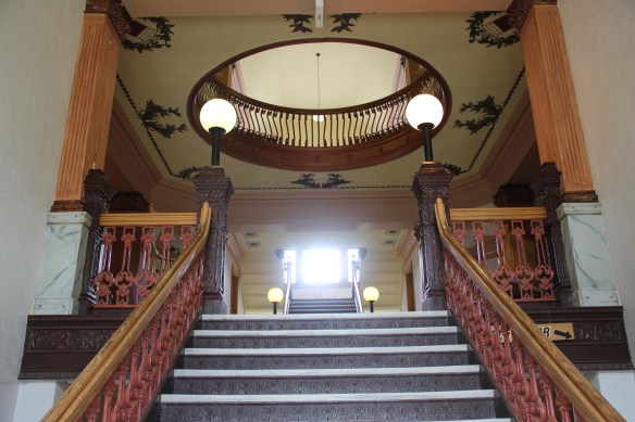
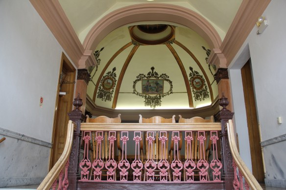
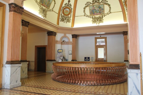
 in Montana is the lavish interior of the central lobby and then the upper story dome. The decorative upper dome frescoes come from a Milwaukee firm, Consolidated Artists. Newspaper accounts in 1900 recorded that the completed courthouse cost $100,000.
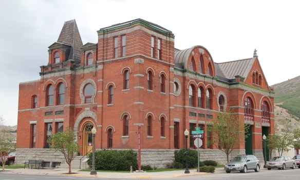 The bombastic classicism of the courthouse was at odds with the earlier more High Victorian style of City Hall, built 1895-1896, and attributed to J. H. Bartlett and Charles Lane. But classicism in the first third of the 20th century ruled in Anaconda’s public architecture, witness the Ionic colonnade of the 1931-1933 U.S. Post Office, from the office of Oscar Wenderoth.

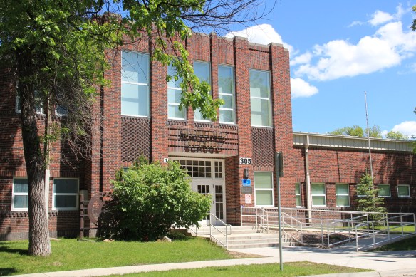
Public schools in the first third of Anaconda’s development also reflected Victorian traditions, such as the understated Collegiate Gothic of the Junior High School, 1927-1928, from the Great Falls architectural firm of Shanley and Baker.
 Once Anaconda, bursting at the seams following the boom of World War II, chose to upgrade its public schools, it took a decided turn away from traditional European influenced styles and embraced modernism, as defined in Montana during the 1950s.
 The long, lean facade of Lincoln Elementary School (1950) began the trend. Its alternating bands of brick punctuated by bands of glass windows was a classic adaptation of International style in a regional setting. The modernist bent continued in 1950-1952 with the Anaconda Central High School, the private Catholic school, now known as the Fred Moody middle school, only a few blocks away. Except here the modernist style is softened by the use of local stone, giving it a rustic feel more in keeping with mid-20th century sensibilities and the Catholic diocese’s deliberate turn to modern style for its church buildings of the 1950s and 1960s (see my earlier post on College of Great Falls).


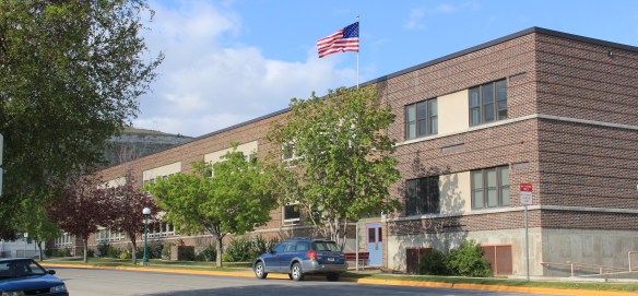
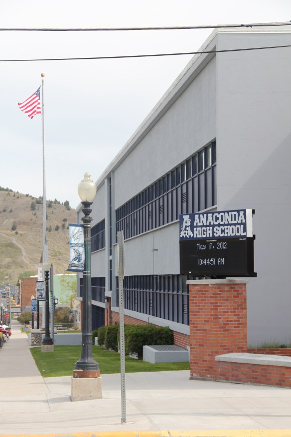
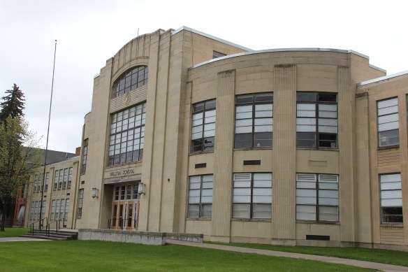
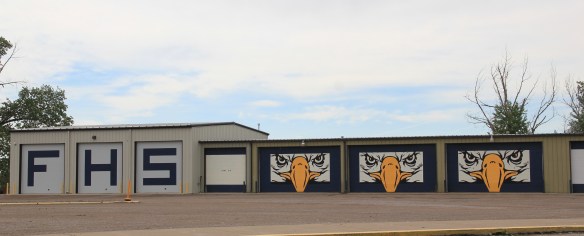
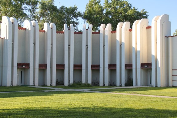
The celebration of symmetry in a factory-like style advocated ed by some mid-20th century modernists is no better stated than in the Anaconda Senior High School, the public high school completed in 1954-1955 and designed by the Montana firm of J. G. Link and Company.

If anyplace in Montana better conveys the post-World War II turn in public education to resemble the corporate ethos beginning to dominate American culture it is this high school building. From the railroad depot, at the bottom of Main Street, one catches a glimpse of the long horizontal facade, and immediately think–there’s a corporate office, maybe a factory, up the street. This is one interesting building.
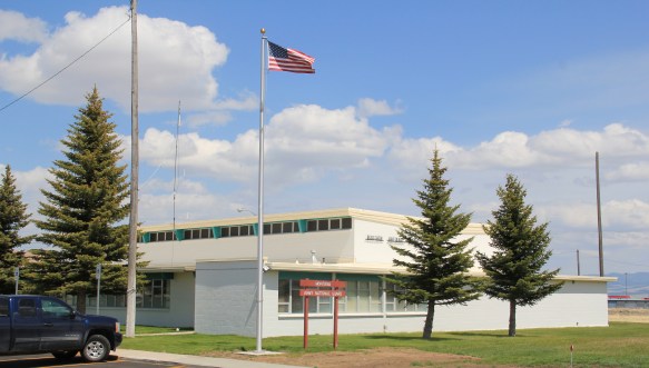
So too is a very different building as to purpose but not to style, the National Guard Armory. Appropriated by Congress in 1960 and built in 1961 for an estimated $66,000, the armory is a functional concrete building that speaks well to the style of modernism so often associated with military buildings of the Cold War era.


 Then Senator Moss took me for a quick tour of its late 1990s renovation in 2007–its conversion into law offices respected both its original spaces and interior design.


 Manhattan was not originally Manhattan, but named Moreland, as discussed in an earlier blog about the effort to build a barley empire in this part of Gallatin County at the turn of the century by the Manhattan Malting Company and its industrial works here and in Bozeman. But the existing railroad corridor, along with the surviving one- and two-


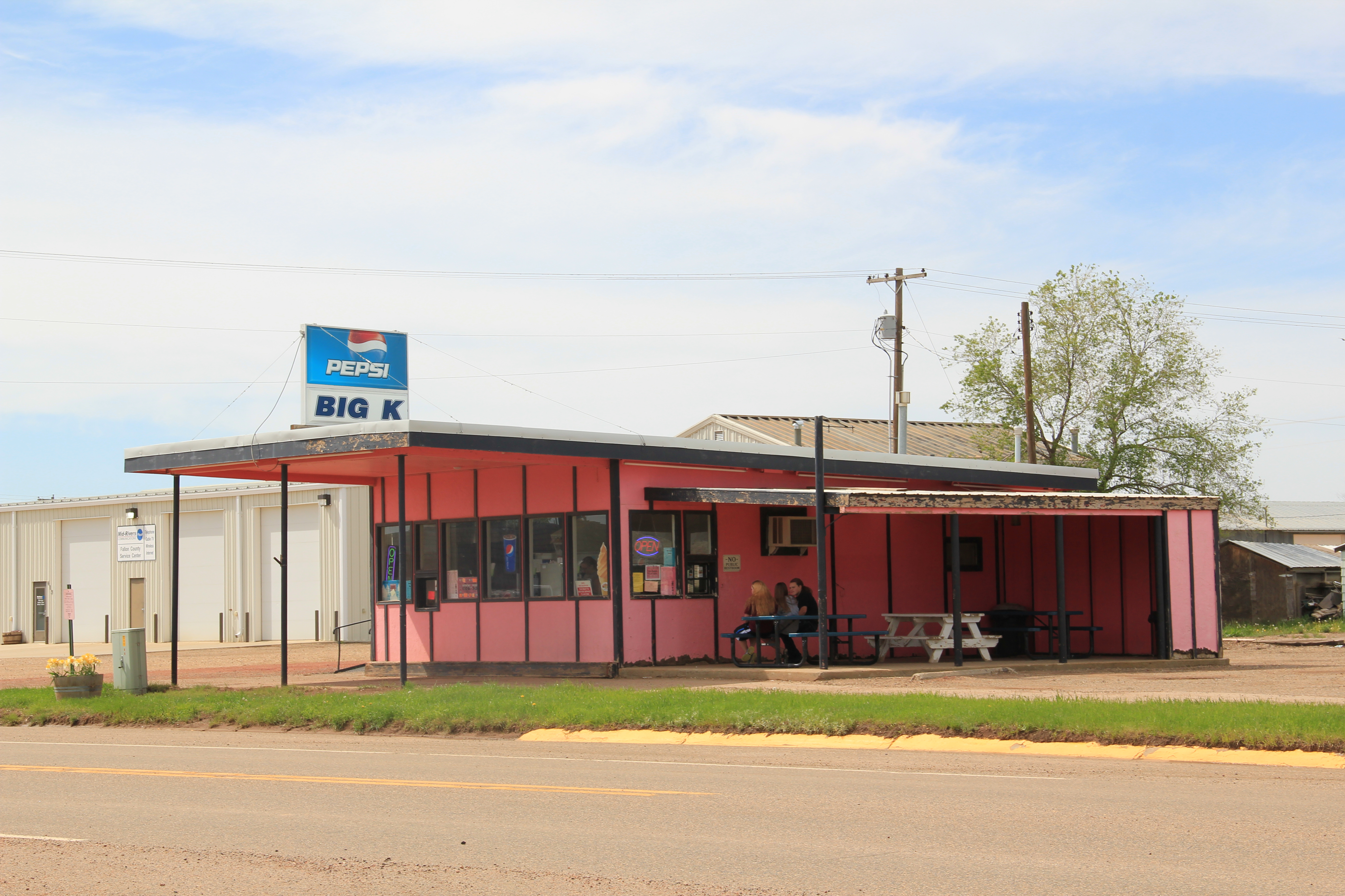
 The historic auto garage from c. 1920 above is one of the most significant landmarks left upon old U.S. 10, and I am glad it is still used for its original function in the 21st century.


 But it has many positives in place to keep its character yet change with the times. Many residents are using historic buildings for their businesses and trades. Others are clearly committed to the historic residential area–you can’t help but be impressed by the town’s well-kept historic homes and well-maintained yards and public areas.


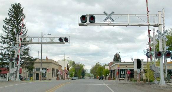
 U.S. Highway 89 enters the Blackfeet Indian Reservation on its southern border, heading for its junction with U.S. Highway 2 and the reservation center of Browning. Before the junction, you cross the historic Two Medicine River, a historic corridor for the Blackfeet. To the west of the river crossing is a highway historical marker for Coldfeet School, a one-
 room school (not extant) built for Blackfeet children in 1933 during the New Deal. To the east of the highway river crossing, however, was one of the earliest schools (1889) on the reservation, the Holy Family Catholic
")


 This panorama of the mission site today shows that neither of the dormitories remain, although the historic frame barn and mill still stand (to the left) while the chapel is still a dominating element, and has been incorporated into present-day Blackfeet culture. It is in excellent shape.
 Another change is that the Blackfeet provide public interpretation of the site, through their own historical markers, which is extended into the adjacent historic cemetery, one of the most somber places in the region. The old mission is now part of the reservation’s heritage tourism effort.
 Returning to U.S. 89 and heading northwest, you head to the junction of U.S. Highway 2 and the town of Browning. The town is a center for reservation education, as shown by the new campus for the Blackfeet Community College.
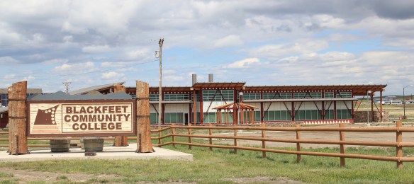 Here too is another historic Catholic Church, the Little Flower Catholic Church, built in 1931, from locally available stone in a Gothic Revival style. The congregation supports a small Catholic school next door.
 The Browning fairgrounds is an important Blackfeet recreation and cultural center, with this recent installation again providing public interpretation of Blackfeet culture.
 and U.S. 89, heading north. It created an appropriate, respectful way for the increasing number of auto tourists headed to Glacier National Park to learn about the Blackfeet in particular and Plains Indian culture in general. The famous mid-20th century anthropologist, John Ewers, had worked tribes to create the museum’s initial exhibits and collections. In the 21st century, the Blackfeet have developed additional institutions to take advantage of tourism through the nearby Glacier Peaks casino and hotel, a complex that has developed from 2011 to 2015.
 These new buildings are part of a long-term continuum of tourism in Browning, starting with this old concrete tipi, built originally as a gas station in 1934 and now converted into a coffee shop. And the Blackfeet
 Trading Post is a business found in all sorts of national park gateways–the classic place to get cheap souvenirs and t-shirts of all types, not to mention moccasins and all of the stereotypical material culture of Native American tourism in our country.
 the primary voice on what the park means, and how visitors can think about it today. The Native American presence on U.S. Highway 89 today is much more evident, with much more public interpretation, than in my travels 30 years ago.
 We just finished an exploration of U.S. Highway south from Great Falls to Livingston, the gateway to Yellowstone National Park. Now let’s head in the opposite direction, north of Great Falls to Glacier National Park. In the first half of this trek, one great man-made landscape dominates either side of the road–the Sun River Irrigation Project, established by the U.S. Bureau of Reclamation in 1906 but not completed until the late 1920s.

 Feeding in and out of Fairfield are multiple canals and ditches, with the great bulk of land devoted to the production of malting barley, under

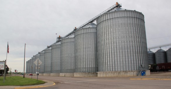 Fairfield itself is a classic T-plan railroad town. The barley granaries dominate the trackside, where also is located the headquarters for the Greenfields Irrigation District, so designated in 1926.
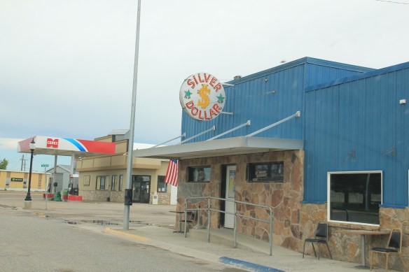
 Along the stem of the “T” plan are all of the primary commercial buildings of the town, from an unassuming log visitor center to various one-story commercial buildings, and, naturally, a classic bar, the Silver Dollar.


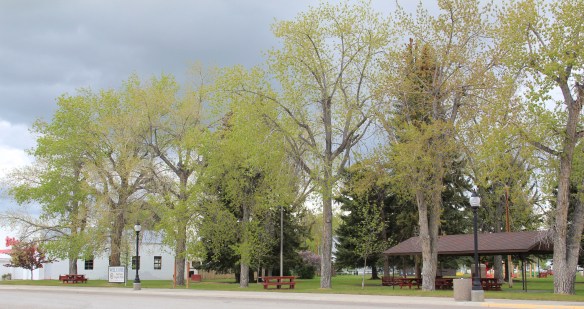
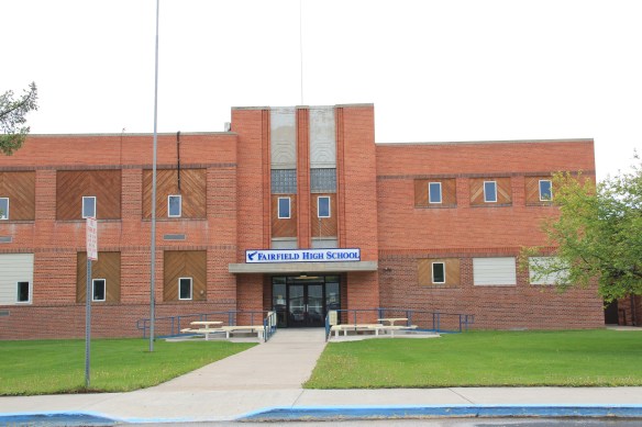
 Public spaces and institutions are located at the bottom of the “T,” including a community park and swimming pool, a c. 1960 community hall, and an Art-Deco styled Fairfield High School. The park, pool, and high school were all part of the second period of federal improvement at Fairfield during the New Deal era.

 Continuing west you soon encounter post-World War II service stations and motels, some updated, some much like they were, on the outskirts of town and then, boom, you are in the heart of Livingston, facing the commanding presence of the Northern Pacific depot complex with warehouses–some now converted to new uses–coming first and then
 massive passenger station itself. Opened in 1902, the passenger station was an architectural marvel for the new state, designed by Reed and Stem, who would continue on to great fame as the architects of Grand Central Station in New York City. The station, interestingly, is not Classical Revival in style–certainly the choice of most architects for their grand gateways along the nation’s rail line–but a more restrained interpretation of Renaissance Revival style, completed in red brick.
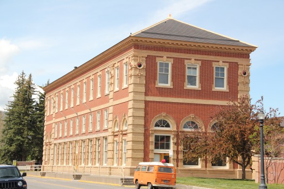 The building is not particularly inviting for locals coming from the business district to the depot–that was not its primary audience. Rather the grand entrance is track side, where passengers headed to Yellowstone National Park could depart for food, fun, frivolity, whatever they needed before the journey into the wildness of Yellowstone.
 Travelers were welcome to use the grand covered walkways to enter the depot proper, or to take a side visit to the railroad’s cafe, Martin’s as I
 knew it back in the day, a place that rarely slept and always had good pie. The cafe changed its orientation from the railroad to the road as automobile travelers on U.S. 10 began to dominate the tourist market. Now it has been restored as a local brew pub.
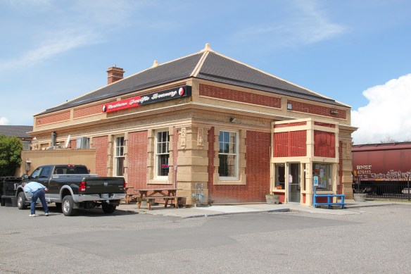


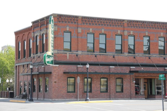 Directly facing the center of the passenger station was the mammoth Murray Hotel–a flea bag operation in the 1980s but now recently restored as a hipster place to be, especially its signature bar.

 Imagine my pleasant surprise last year when I found that Gil’s still existed but now had been converted into a decidedly up-scale establishment, far removed from the 1980s.
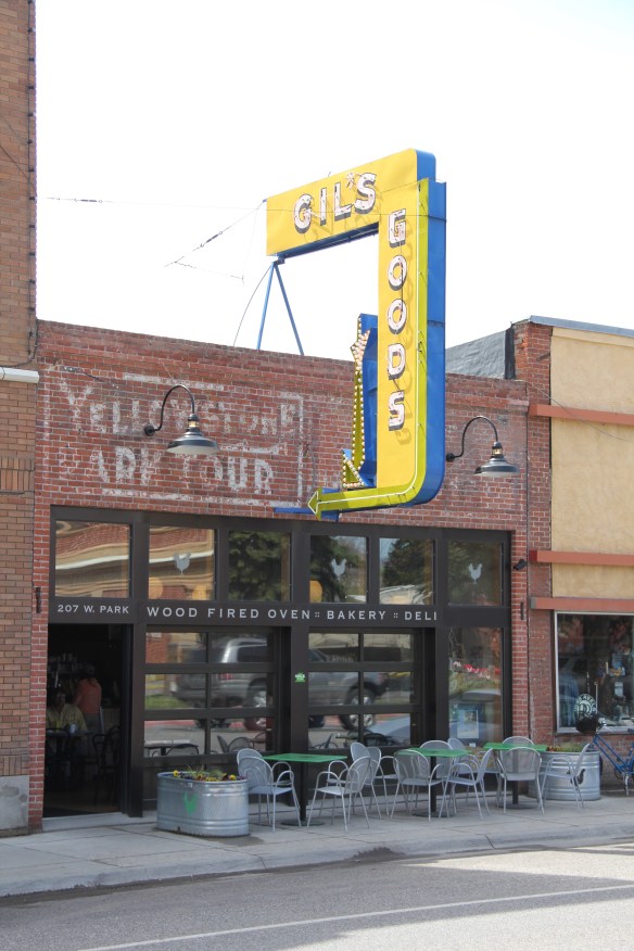 I don’t know if I have encountered a more fundamentally changed place–cheap trinkets gone, let the wood-fired pizzas come on.
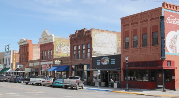 I was not so blinded in 1984 by the concept of the “metropolitan corridor” that I ignored the distinctive Victorian storefronts of Livingston–how could I since they all, in a way, fed into the tracks. But when I got to the end of that distinctive business district and watched the town, in my
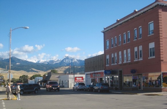 mind, fade into the Rockies, I had captured the obvious but had missed the bigger picture–that’s the next story.
 As the highway leaves the central plains east of Great Falls, it heads east through coal country (see the earlier post on Belt) and south into the Little Belt Mountains and the old mining towns of Monarch and Neihart (above). Both Cascade County towns are proud of their heritage, a story embodied in the Monarch-Neihart School, a wonderful bit of log craftsmanship from the New Deal era, a WPA project finished in 1940 that is listed in the National Register of Historic Places.


 When I last visited there in 2015 the combined route of U.S. 89 and 12, which passes in front of the courthouse and the center of town, was being rebuilt, giving the historic business district the look of a ghost town.

 U.S. Highway 89 continues south, crossing the historic corridor of the Milwaukee Road at Ringling, another Meagher County town discussed in an earlier post, marked by the landmark St. John’s Catholic Church.
 Travelers continuing south soon find themselves in Park County, entering the Shields River Valley just north of Wilsall, where highway markers and monuments, like that for “Thunder Jack” (2006) by sculptor Gary Kerby, convey the significance of the place.
 Wilsall was not much a place 30 years ago, a small trade town on the edge of a Northern Pacific Railroad spur line, a past still recalled by the tall elevator and old railroad corridor.
 But the growing popularity of the Shields River Valley has led to a new boom in Walsall, with old banks converted into bars and old general stores


 Clyde Park Tavern is still the place to go for an adult beverage, or two. Historic grain elevators still serve local ranchers, marking the railroad line that defined the town’s landscape until the impact of the highway in the early 20th century.


 project, and the Art Moderne landmark Intermountain bus station–once so proudly featured in the Clint Eastwood and Jeff Bridges movie, “Thunderbolt and Lightfoot,” part of that decade from the mid-1970s to mid-1980s when Montana was suddenly in the lens of Hollywood.
 All of these buildings and places help to give Great Falls its unique sense of self, and its sense of achievement and promise. And that is not to even mention the fun, funky stuff, such as the Polar Bears and having the
 supper club experience of 50 years ago at Borrie’s in Black Eagle. Stepping back into time, or looking into a future where heritage stands next to the
 atomic age, Great Falls and its environs–from Fort Benton to the northeast to Fort Shaw to the southwest–can give you that memorable heritage area experience.