Denton: Fergus County’s Agricultural Trade Centers

IMG_9892

Fergus County, with Lewistown as the county seat, lies at the heart of Central Montana.  Although gold and other precious minerals were found at Maiden and other sites in the early years, the region grew once the railroads came at the turn of the century.  More than a dozen substantial agricultural trade centers, all connected to Lewistown by the rails, soon surrounded the county seat.  When I surveyed the region in the 1980s, the continued vitality of these towns impressed–and they still deserve a close look today.

Denton Fergus Co

In 1984 I came looking for railroad depots, frankly, but was blown away by the Farmers State Bank, one of the best “strongbox” style of small town banks I had encountered anywhere in Montana.  The town then was in a pattern of slow, steady decline, from a high of 435 residents in 1950 to 356 in 1980.  That rate in most Montana country towns meant that the bank was long gone–but here it remained and stood proudly along Highway 81.

IMG_9884

Thirty years later, the bank building still made its statement of permanence in materials (brick) and in style along the highway.  Indeed, the town’s population had continued to slip downward, especially in the last 20 years, reaching a mere 255 residents in the last census.  But the bank remains–and even has a new addition to the rear of the building.

IMG_9885

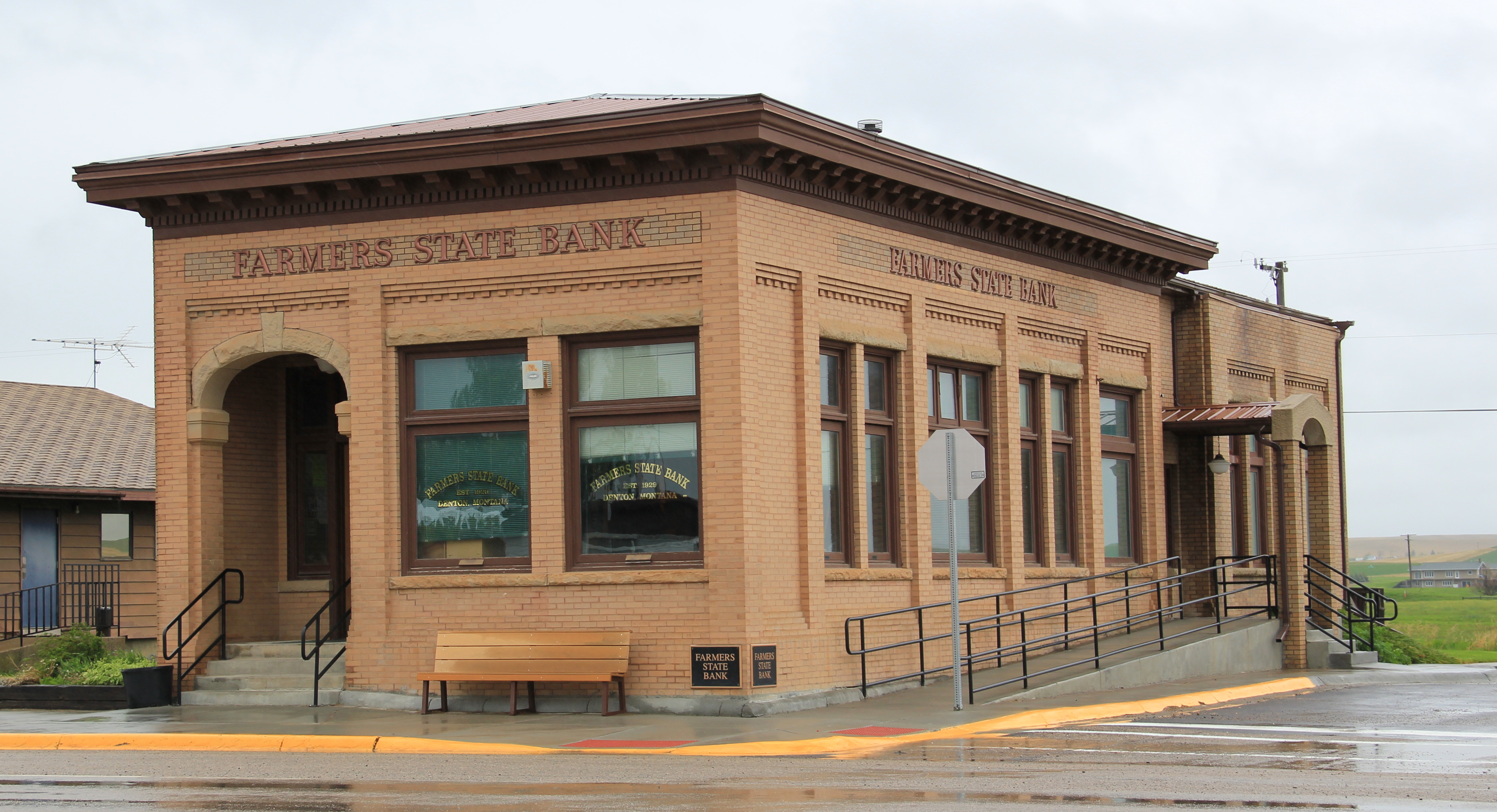
I passed by this iconic Fergus County building in late May of this year, just weeks after the completion of its merger with Dutton State Bank (another great building to be discussed later).  All was well: it remained one of Denton’s anchors.

IMG_9896
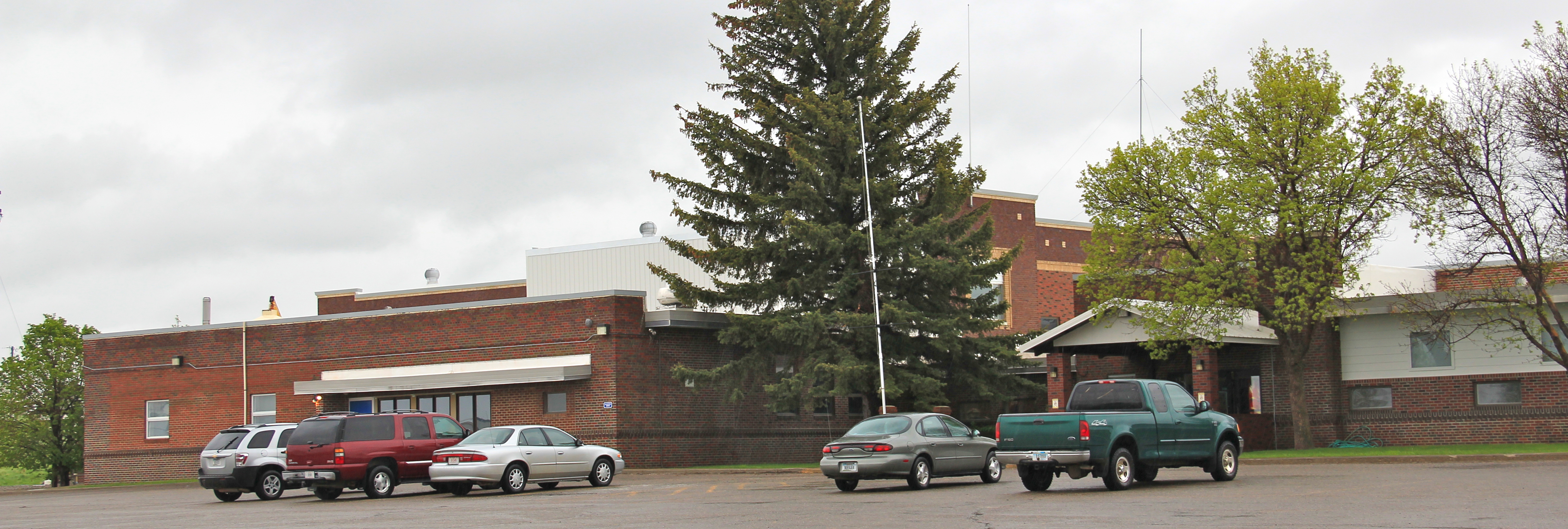
The town’s schools are another important anchor.  The football field (see the first image) serves as the eastern gateway to Denton; the schools are bunched together as though they grew organically from that spot one hundred years ago and have evolved ever since.

IMG_9880

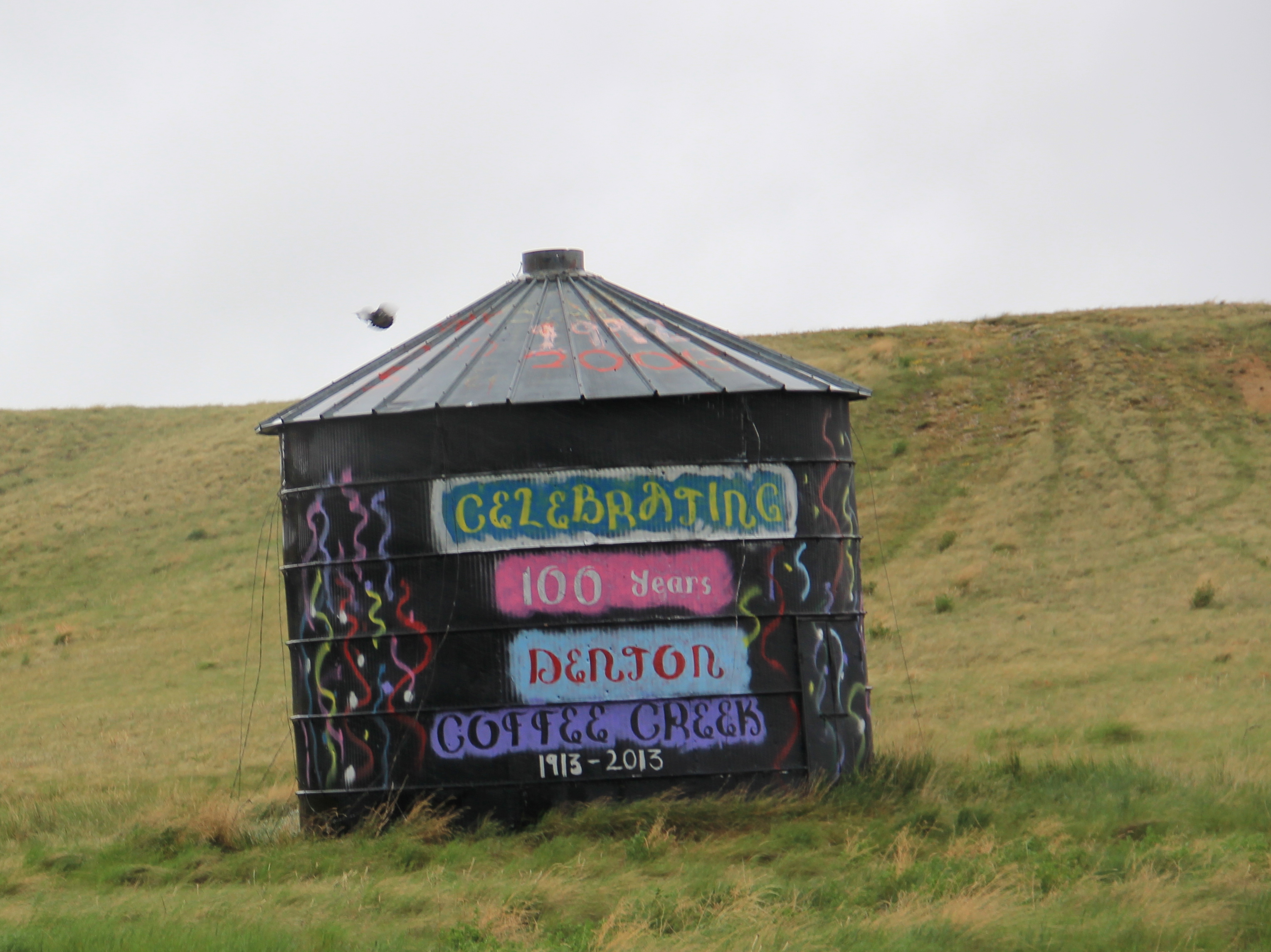
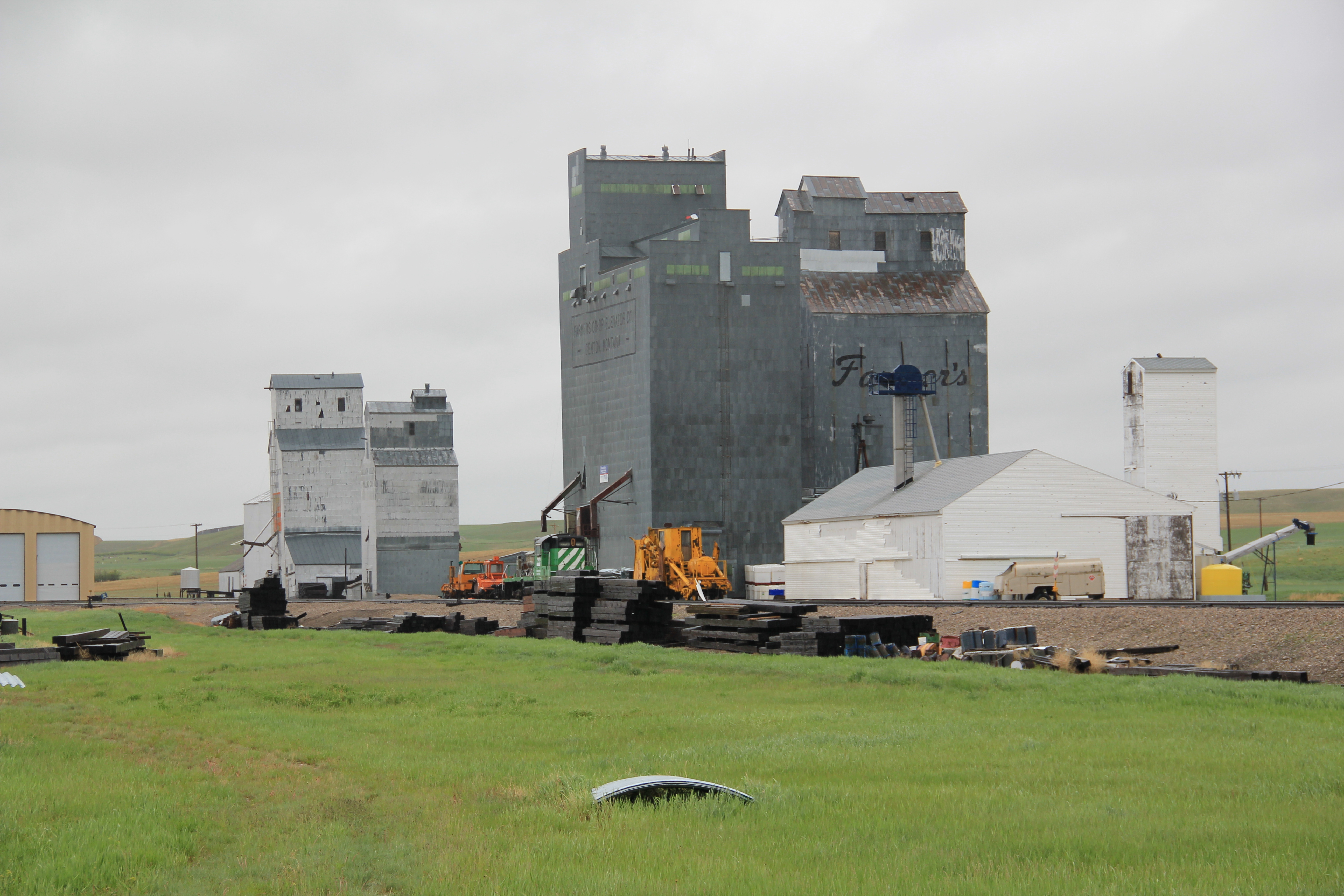
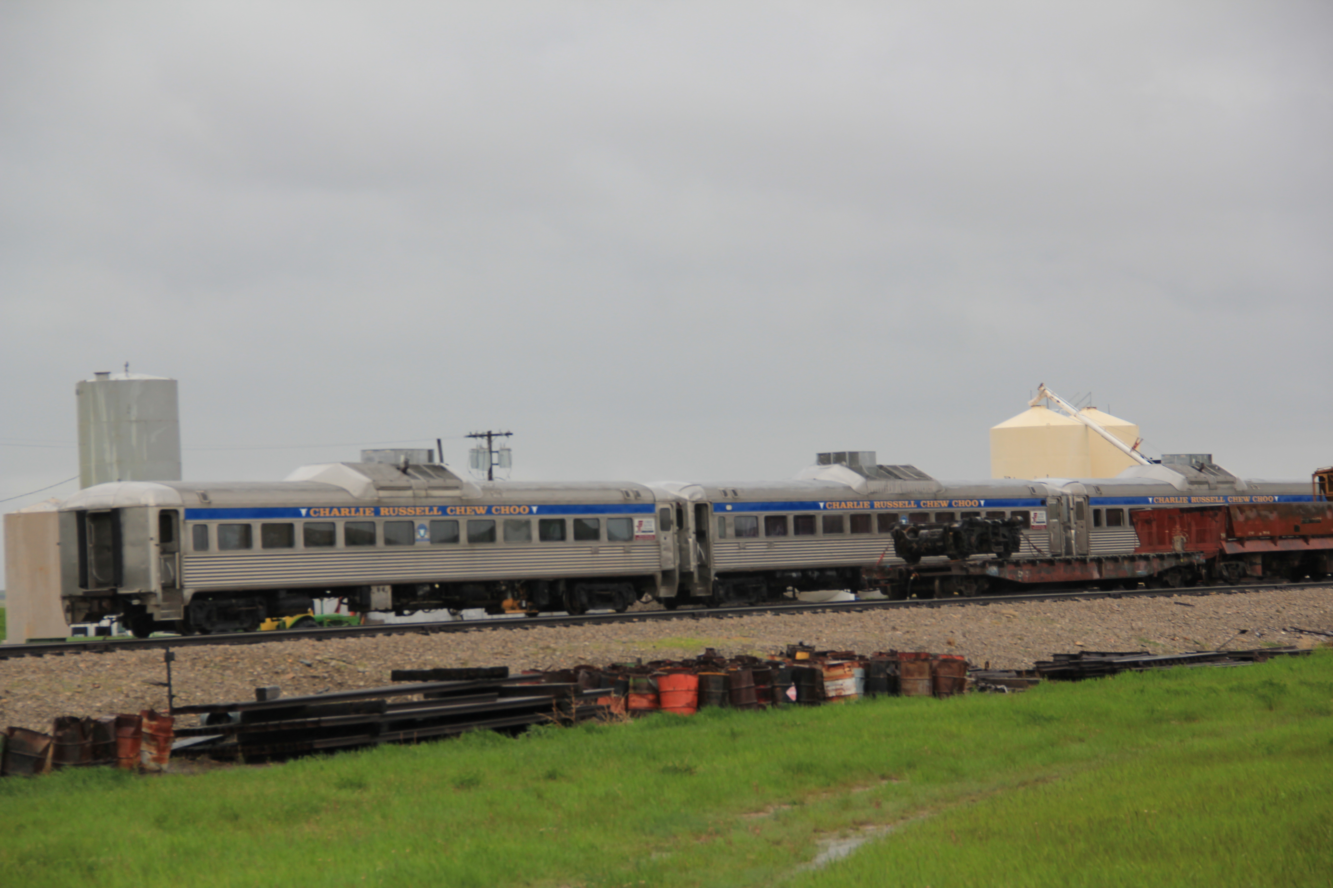
True, Denton and its neighbor to the west Coffee Creek celebrated their centennials in 2013.  And it was appropriate that a granary announced this fact since grain is king here. The elevators standing along the old Milwaukee Road line still boldly state the importance of agriculture to Denton. Even after the Milwaukee ceased operations in 1980 state officials worked with local governments and ranchers to create a new Central Montana line, which kept the elevators running, and in more recent times, has made Denton the western terminus of the popular Charlie Russell Choo-Choo excursion train.

IMG_9881

IMG_9882

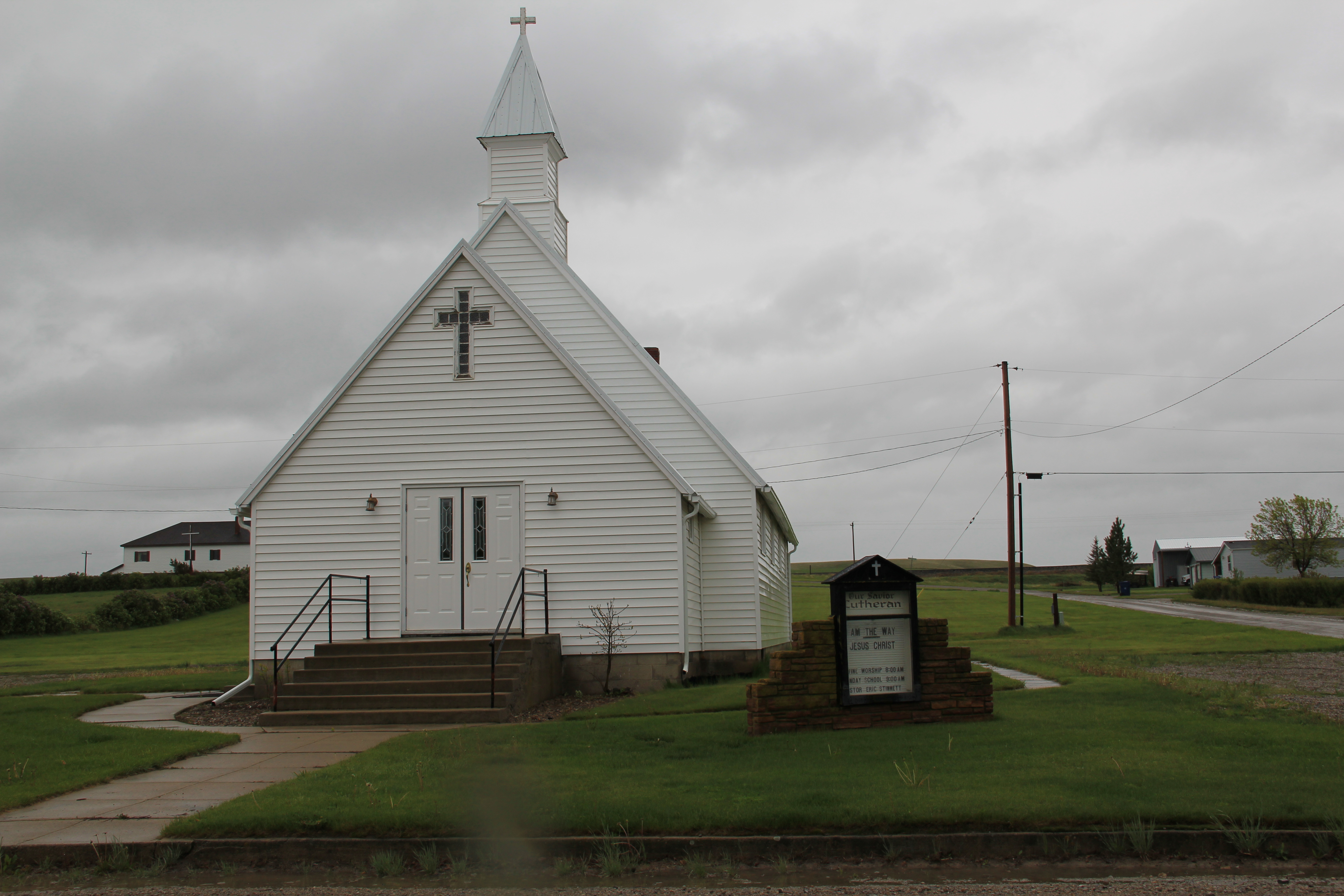
Schools, a bank, and grain elevators are anchors but Denton also has maintained vibrant cultural institutions from its town library, housed in a brilliant c1960 building, and churches such as the historic Gothic-styled Our Savior Lutheran Church and St. Anthony Catholic Church.

IMG_9887

IMG_9897

IMG_9898

Residents also have kept the local Masonic Lodge in operation, housed in the 2nd floor of the post office building, which, due to its overall neoclassical style-appearance and corner lot setting, was probably a bank building built shortly after Denton became a town in 1913.

Fergus Co Denton post office and masonic hall  - Version 2

Toston: Another Northern Pacific Town in Broadwater County

IMG_7073

Toston has become a forgotten town of the Northern Pacific Railroad line as it stretched from Logan, in Gallatin County, through the headwaters of the Missouri River and into the broad Missouri River valley of Broadwater County. Today Toston is best known to travelers of U.S. 287 as a scenic stop on the Missouri River, and the access to Toston Dam reservoir, a project of the U.S. Bureau of Reclamation.

IMG_7069

The town’s heyday came early, especially with the discovery of pyrite goal ore at Radersburg to the west in the Elkhorn Mountains and the establishment of a smelter at Toston in the late 1880s.  In the 21st century the old smelter site has received a superfund clean-up and a large interpretive marker explains the smelter and its impact on both Toston and Radersburg, another good example of the much better public interpretation you can encounter on the Montana landscape.

IMG_7074

At the Missouri River fishing access, Montana Wildlife and Park erected another interpretive marker, a huge boulder marking the location of the Lorentz homestead.  William B. Lorentz was the Northern Pacific’s agent in Toston and he filed for a homestead along the Missouri south of the tracks in 1887.

IMG_7070

Toston had a second economic boom during the homesteading era when state officials decided to build a new steel truss bridge over the Missouri River.  The Toston Bridge was listed in the National Register of Historic Places in 2005.  Its interpretive marker records that state engineer Charles A. Kyle designed “a riveted steel Warren through truss design”

IMG_7072

for the bridge in 1918, with Security Bridge Company of Billings as the contractor.  The Billings company used 11 local residents, including William Lorentz, the former Northern Pacific station master. and the bridge was opened in the summer of 1920. Soon thereafter, the Bureau of Reclamation announced its intention to create a new irrigation project, initially called the Townsend Bench project. Reclamation officials designed a project for what they called 15,000 “excellent acres,” irrigated by a gravity system with the diversion dam located east of Toston on the Missouri River, identified today as the Crow Creek Pump Unit.  Consequently, Toston has several buildings remaining from the first two decades of the 20th century, including concrete block commercial buildings and the town’s most impressive building, a two-story frame school, which is now a private residence.

IMG_7079

IMG_7078

With the irrigation project came a set of large grain elevators, which in 1984 dominated the highway view of Toston along U.S. Highway 287. These have been demolished.  One historic church building, I believe it is a Methodist Church, remains but does not hold services.

IMG_7076

The Toston Bridge kept the town vibrant since its location meant that all traffic between Helena and Bozeman on U.S. Highway 287 passed over the bridge, over the tracks, and through the middle of town.  In 1955, however, a new bypass bridge was constructed and Toston began a decline that has slowly drained away most of its population.  At the 2010 census, it had 108 residents.

IMG_7080

Townsend: A Railroad Town on the Missouri River

IMG_9524

Townsend is a classic Montana crossroads town, with its historic heart, and primary commercial district, centered on the intersection of U.S. Highways 12 and 287.  But a closer look reminds you of the town’s origins as a railroad town, part of the Northern Pacific route, as it moved westward from Bozeman to Helena, Montana, along the valley of the Missouri River.  The town’s layout is a good example of a T-town plan, with Front Street (now U.S. 287) forming the top of the “T” while Broadway (U.S. 12) forming the stem, as shown above.

IMG_9529

Grain elevators and other light industrial and transportation-related buildings the lots between the railroad tracks and Front Street.  At the corner of the highway junction is one of the town’s oldest buildings, the Commercial Hotel of 1889, which still operates today as

IMG_9528

a bar and restaurant.  Historically this large two-story frame building, with hipped roof dormers creating even additional rental space under the roof, would have been an attraction for travelers and business people looking for a place just off the tracks, or later the highway. It is among a handful of late 19th century railroad hotels left in Montana.

IMG_7092

Broadway also had its historic landmarks, especially the neoclassical-styled State Bank of Townsend, which is listed in the National Register of Historic Places.  Dating to 1918, the building’s architect was the Albert Mooreman and Company firm from St. Paul, MN. The flanking two-story classical columns root the yellow brick building to its prominent corner lot–the bank’s survival into the twenty-first century is also a rarity in rural Montana.

IMG_7111

Broadway also has its mix of one- and two-story business buildings, from the American Legion and another Montana Mint Bar to the Professional Building of 1911.  Despite its proximity to both Helena and Bozeman, the town has retained its commercial vitality.

IMG_7107

IMG_7096

IMG_7112

At the end of the commercial district is the Broadwater County Courthouse, a mid-1930s New Deal project that has expanded significantly in the three decades since I carried out the original historic preservation plan survey in 1984-1985.  Its understated Art-Deco styling fits well its highway location.  And as to be expected in a “T-town” plan, its location at the end of Broadway, meaning the end of the stem of the “T” reflected well the comparative power between local government and the corporate power of the railroad.

IMG_9521

IMG_9522

Being a resident of Helena from 1981 to 1985, I passed through Townsend many times on my way east since US 12 was a favorite trek.  I noticed these major landmarks and the patterns of railroad town plans but I must admit that I never strayed off of either Front Street or Broadway, and that was a mistake.

IMG_7099

IMG_7103

IMG_7102

South of Broadway are several valuable late-19th or turn of the century Victorian-styled residences, some of which have found their champions and have been restored while others need that champion to see the potential jewel underneath decades of change.  One historic neighborhood school building–now a Masonic lodge–also remains, along with many different churches, most of which date to the second half of the twentieth century.

IMG_7105

North of Broadway is a notable exception, the Victorian Gothic styled Townsend United Methodist Church, again an important survivor from the town’s opening generation of history.

IMG_7110

Townsend also had a set of interesting bungalows from c. 1920 on U.S. 12 as it moves east of the courthouse.  These are made of concrete block, shaped to mimic stone masonry.  It was a popular technique to give a house a solid, permanent look, and you tend to find it more in the west than in the east.  Of course, Townsend was not far from the major concrete works at Trident–a topic for a later posting.

IMG_7119

IMG_7120

Last but not least Townsend, and Broadwater County, has an active historical society and local museum, established during the American Bicentennial in 1976–and expanding ever since at its location behind the county courthouse.

IMG_7123

A second look at Ringling

IMG_9499

Ringling, a stop along the Milwaukee Road in northern Meagher County just off U.S. Highway 89, served as the eastern gateway for the railroad’s move west into the Rocky Mountains along its electric line.  From Ringling the Milwaukee passed through the famous Sixteenmile Canyon then crossed the Missouri at Toston and began its ascent in the copper kingdom of Butte.

IMG_9512

I had last passed quickly through the village in 2011 and its iconic Milwaukee Road combination depot was weathered but appeared as if it would yet survive for sometime.  Within four years, however, its fate was much more uncertain.  Roof decking is missing–will this now rare survival of the railroad’s corporate stamp on the northern plains survive till the end of the decade?

IMG_9509

IMG_9508

Brumfield’s Garage is more an example of roadside architecture from the first half of the twentieth century than a building that dates back to the Milwaukee’s heyday.  Its vernacular interpretation of Art Deco styling by means of the four brick pilasters catches the eye–this adaptable property has been many things, and in my past visits has served as a store and as a bar.

IMG_9504

Ringling also retains its school–now a residence–another of the remarkable rural frame standardized designed schoolhouses found throughout central Montana. It sits south of the depot, as if the corporate and the public defined the north-south boundaries of the village.

IMG_9501

Still overlooking the town, and serving as an important landmark on U.S. Highway 89, is the historic Arts and Crafts-styled St. John’s Catholic Church, to which I have already devoted one post in this blog.  What I was pleased to find in 2015 is that some preservation work was underway–with weatherboards being repaired and replaced.  With a decent roof and a recent paint job, the church is in much better shape than many of its brethren across the region. The continued use of this Montana plains church as a “community church” is the best way to keep it alive in the 21st century even as the rest of Ringling shrinks and disappears from the Meagher County landscape.

IMG_9495