 Let me just jump right in: I do not know of another town in Montana that has done more with the concept of heritage development than Butte in the last 30 years. Heritage development, in brief, means that a community identifies the stories and places that define their past and sense of identity and then uses them as tools for community revitalization and growth. The stories and places must be authentic, meaningful, real–fake pasts don’t get you very far. In 1981, out of fears that its storied and nationally significant history would be lost in the haze of late 20th century urban renewal and economic change, Butte created as part of local government the Butte-Silver Bow Archives–everyone I knew were excited about its potential and its early discoveries at the time of the state historic preservation plan work in 1984-1985. Now that institution is one of the key rocks upon which Butte’s future lays. Above is the conversion of a historic firehall into the modern archives/heritage center the institution is today–in itself a great example of adaptive reuse and historic preservation at work.
Professional staff and volunteers, all led by Ellen Crain, keep both the community and scholars engaged–the number of strong histories, public projects, and exhibits that have come, in whole or in part, from this place in the last 30 years is very impressive. Plus it is
 a vibrant institution, always in touch as its community room hosts other heritage groups and special programs throughout the year. The archives is just around the corner from one of the most important, and solemn, places in the city, the location of the Butte Miners’ Union Hall, which was bombed in 1914.

Now an interpretive monument talks about the union, the bombing, and addresses directly a chilling chapter in the long struggle between labor and capital in Butte. Installed c. 1993 near the “top” of Main Street, this site sets the stage for the amount of public interpretation found in the city today.
 Heritage development has become part of the basic sinews of Butte. Along with its active archives board, the city also maintains an effective historic district commission, and provided seed money for several key projects over the past generation. The Original Mine site below, the city’s first copper mine, not only serves as part of the city’s public
interpretation efforts, it is also a place for community gatherings, such as the Montana Folklife Festival in recent years. It is important to note that the marker at the Original just doesn’t celebrate the technology it also notes how many men–43–died at that mine. The progress of Butte happened on the back of its working class miners.
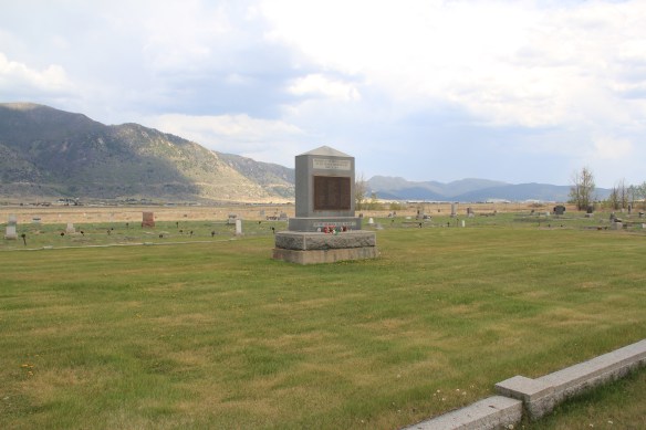
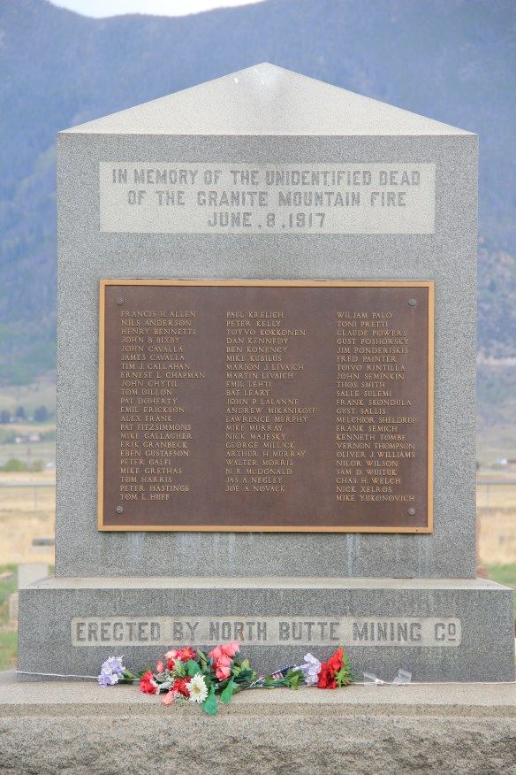
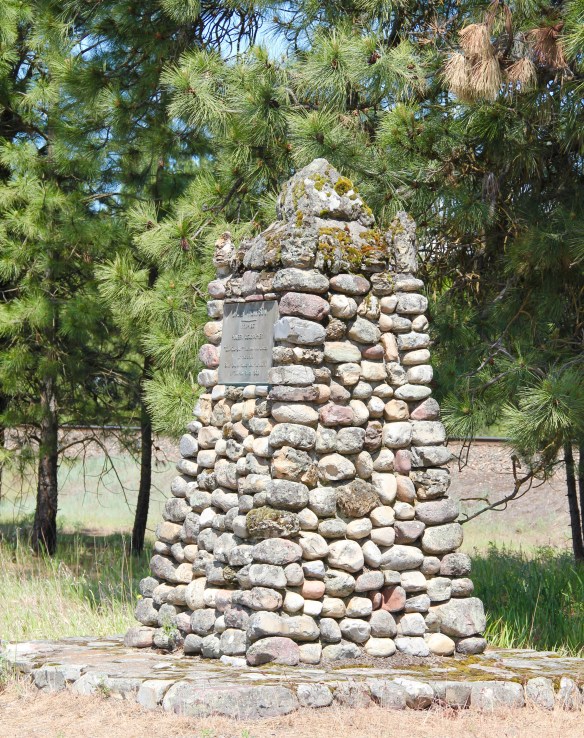
Here is another promising change: the willingness to landmark and discuss the human costs of mining. Butte’s most infamous event was the Granite Mountain/ Speculator Mine disaster of 1917 in which 168 miners died–still the single most deadly disaster in American hard-rock mining history. Not that the event was ignored at the time. In fact the North Butte mining company erected the memorial above to those who perished in Mountain View Cemetery, far from the scene, shortly thereafter. Who knew this memorial existed? There were no signs marking the way there–you had to search to find it.
 Today the Granite Mountain site is one of the best interpreted mining properties I have encountered. The miners’ stories are told–often with the words they were able to write down before dying from the lack of oxygen–and their multiple ethnic backgrounds are acknowledged, and celebrated.

 The interpretive memorial overlooks the mine, and is located high over town. But when I visited in May 2012 a school group was there too, along with visitors like me.
ARCO, along with public partners, funded the site in this century, as part of the general Superfund cleanup of the mining district. But the park was long overdue as well as the recognition that some 2,500 miners lost their lives in the Butte district. The marker’s statement–“you are standing on hallowed ground”–is typically reserved for military parks. Within the context of Butte, however, it is totally justified, and an important point to remember wherever you are in the city.
The reality that Butte’s mines contributed significantly to American war efforts in the 20th century is recalled through a public art mural near a public transit stop. Public sculpture also interprets what was and what has been lost in Butte.
Through the efforts of the state historic preservation office, and its commendable program of providing interpretive markers for National Register properties, the residential side of Butte’s story is also being told. You have to love the “blue” house, associated with U.S. Senator Burton K. Wheeler, one of the New Deal era movers and shakers.
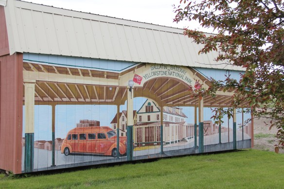
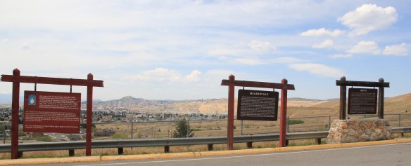 All of these efforts considerably enhance earlier efforts at public interpretation, be they along Interstate I-15 and its overview of Butte or the visitor center maintained just off the
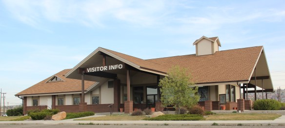 interstate by the local chamber of commerce. The center, yet another change in the last 30 years, is an attractive reproduction of a classic railroad depot design. It also provides a useful perspective of the city from its south side, giving special prominence to the soaring clock tower of the historic Milwaukee Road depot.
 The Berkeley Pit in 1984 was a giant hole in the earth, with a viewing stand. It too now has a more comprehensive heritage experience with a small visitor center/ museum adding to the public understanding of the massiveness and significance of the pit.
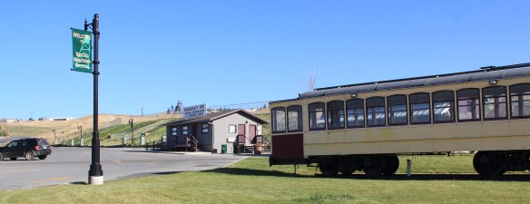
Then of course, designed for highway travelers and tourists, there is the now classic World Museum of Mining, established in 1965 around the Orphan Girl mine. The WMM lets rusting industrial artifacts convey part of the story while the existing mining buildings are open, allowing you to get a more physical experience of what the head frames and mines were really about. And, as typical of Montana museums of the 1960s and 1970s, there is the attached “frontier village,” interpreting what early Butte was all about. Don’t get me
wrong: there are many things to like about the WMM–it is rich in artifacts, as the miners items above suggest (and more about it in another post). But it is a controlled, sterile experience, and I would hate for that to be the only takeaway visitors have about Butte and its significance. The museum is away from uptown Butte, and visitors who stop here may never go explore the deeper story within the town and its historic neighborhoods.
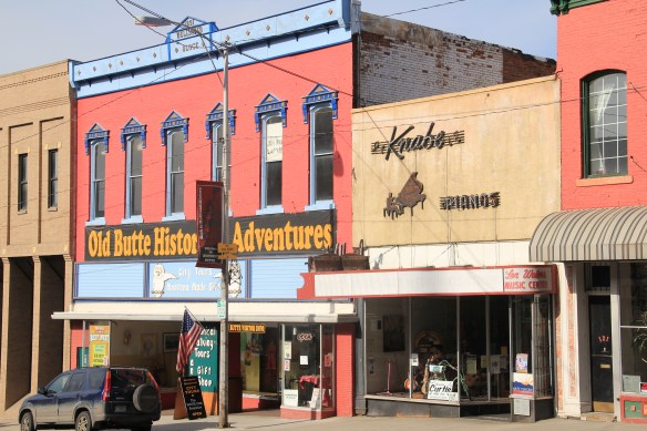
Old Butte Historical Adventures on Main Street is just one group of heritage entrepreneurs who provide visitors with a “up close and personal” viewpoint and experience of Butte’s historic landscape. Walking tours of Uptown along with various special theme tours engage visitors and residents with local history in a way different from traditional monuments, markers, and historic sites.
But one must be aware that the pressure to commercialize can also distort, and demean, the significance of it all. What happens at the Dumas Hotel–a historic brothel–will be interesting to watch. The story of prostitution is very much part of the fabric of the city, but one that for many years people did not want to tell, except with snide references and a snicker or two. Let’s hope that changes as the Dumas is restored and opened as a heritage venue: addressing the sex trade and role of women and men accurately and in context would add immeasurably to the sense of authenticity, of realism, in the Butte story.
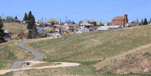
The most exciting part of Butte’s heritage development to my mind are the series of greenways or trails that link the mines to the business and residential districts and that link Butte to neighboring enclaves like Centerville (shown above). Recreational opportunity–walking, jogging, boarding, biking–is a huge component of livable spaces for the 21st century. When these trails are enhanced by the stories they touch or cover,
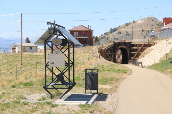
they become even more meaningful and valuable. If you have lived in Montana for 6 months or 60 years, it is time to return to Butte and take the Montana Copperway (trailhead shown above) –not only would it be good for your health, it also gives you a lasting perspective of a mining town within the vast Northern Rockies landscape, and how men and women from all sorts of backgrounds and nations established a real community, one that has outlasted the mines that first created it.


 On the outskirts of town, the 1920s monument to David Thompson was the centerpiece of the town’s heritage tourism attractions in 1984-1985, now it is more of an afterthought. David Thompson was a Welsh-Canadian who established the first trading post in this river valley, called Saleesh House, for the tribe with whom this veteran of both the Hudson Bay Company and North West Company had targeted for the fur trade. His last visit to Saleesh House came in the winter of 1812. Thompson, I thought in 1984, was a very important figure in Montana history but increasingly a neglected trader–in fact most of the early traders, like those of the American Fur Company on the Missouri and Yellowstone Rivers, are neglected, even though significant places associated with them remain intact on the state’s landscape.
 About one hundred years after David Thompson’s last winter at Saleesh House, an entirely different landscape emerged along the Clark’s Fork River, one that introduced the recent technology of electricity to the region. To support and encourage the development of hydroelectric facilities, the city of Thompson Falls combined with investors to build what became known as the “High Bridge,” a way for automobile traffic to cross this gorge in the Clark’s Fork and unite settlement on both sides of the river.
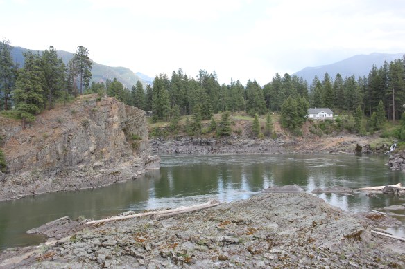 The High Bridge was an early 20th century Montana engineering marvel. It was 588 feet in length, designed for automobile traffic, with a 18-feet wide deck standing on a combination of Pratt and Parker trusses. It is the longest bridge of its kind in Montana.


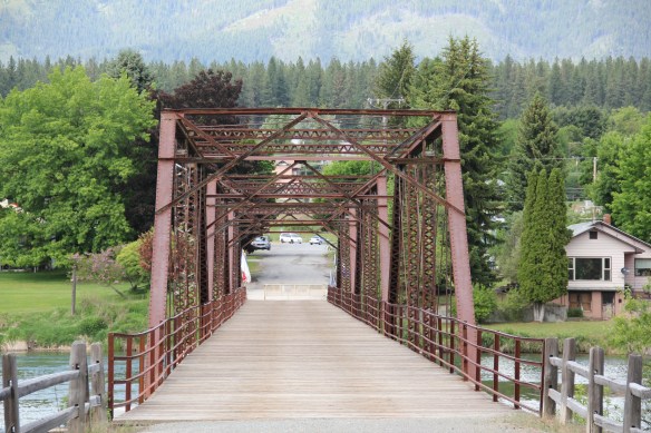 But within two years, residents and officials combined together to place the bridges and hydroelectric facilities in the National Register of Historic Places as a historic district. They were preserved, but still not used, for a generation.
 In 2009-2010, residents worked with local, state, and federal government officials to restore the bridge, add a pedestrian deck, and to open the bridge and either side of the bridge as a public park. Funding in part came from the American Recovery and Reinvestment Act of 2009, one of the ways that short-lived federal building effort benefited historic preservation in Montana small towns.
 The High Bridge experience not only reconnected Thompson Falls to its river roots, it also creates an unique experience for heritage travelers. The site is not that far different from 100 years ago, giving you the chance to cross a river and peer below but also to realize just how “wild” automobile traffic was in the 1910s and 1920s.
 Miners first began to gather at what is now Philipsburg in the late 1860s; the town was later named for Philip Deidesheimer, who operated the Bi-Metallic Mine works. As the Bi-Metallic Mine and Mill expanded operations in the 1880s, a rapid boom in building


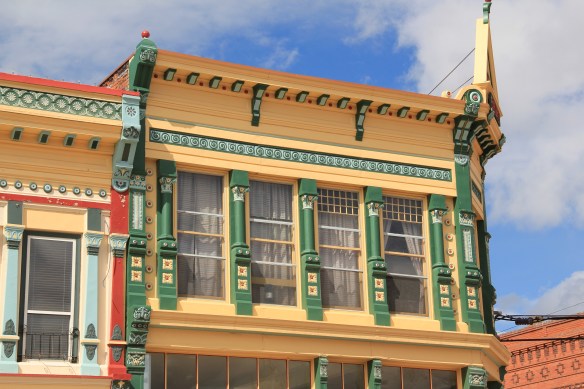 The quality of the Victorian commercial architecture still extant in Phillipsburg, such as the 1888 Sayrs Block above, astounded me during the 1984-85 preservation work. So much was intact but so much needed help. Residents, local officials, and the state preservation office understood that and by 1986 the Philipsburg Commercial historic district had been added to the National Register of Historic Places.
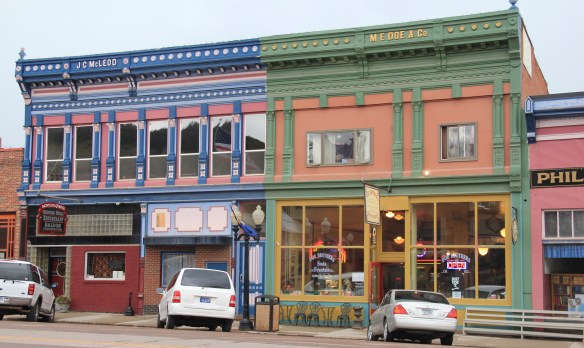 What is exciting is that in this decade, entrepreneurs are building upon early successful renovations and adaptive reuse project to launch new businesses and create new jobs. The town’s population is growing, after 30 years of decline.


 The new developments in Philipsburg are interesting and invaluable changes since 1984-1985. At the same time, I am happy that residents have still embraced their historic public buildings in a similar fashion. The photograph I used in my book about the town in 1985
 was the Philipsburg School, with its soaring tower symbolizing the hopes that residents had for Philipsburg’s future in the 1890s. The historic school, which is listed in the National Register, remains although the community built a new building adjacent to the historic one in 1987. (you can see a corner of the new building at the lower left).
 When I first visited in 1984 the only building in Philipsburg listed in the National Register was the Queen Anne-styled Granite County Jail of 1902. It also remains in use.
 But now the Classical Revival-styled Granite County Courthouse (1913) is also listed in the National Register. Designed by the important Montana architectural firm of Link and Haire, this small town county courthouse also speaks to the county’s early 20th century ambitions, with its stately classical columned portico and its central classical cupola.


 By climbing the hill above the courthouse you also gain a great overview look of the town, reminding you that these rather imposing public buildings are within what is truly a modest urban setting that is connected to the wider world by Montana Highway 1.


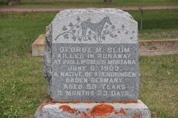
 The Philipsburg Cemetery, which like so many that I ignored in 1984-1985, was a revelation, reflecting the quality of Victorian period architecture found in the town.
 The beauty and serenity of its setting were impressive enough, but then some of the family plots and individual markers reflected Victorian era mortuary art at its best.
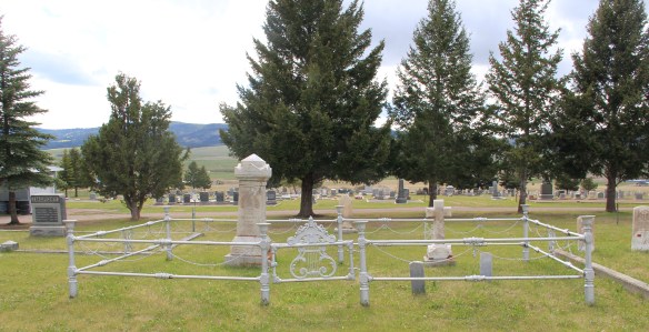 This cast-iron gate, completed with urns on each post and the music lyre gate, is among the most impressive I have encountered in any small town across America. And this cemetery has two separate ones.
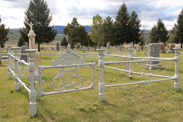 Many grave markers came from local or nearby masons but others, like these for the Schuh and Jennings families, were cast in metal, imitating stone, and shipped by railroad to Philipsburg.


 Three Forks, Montana, is unique in how competing railroads shaped this one small town between the 2008 and 2010. The last post discussed how the Milwaukee Road came first, and its landmark Sacajawea Inn stands at the north end of the town’s main street. On the east side–see the Google Map below–became the domain of the Northern Pacific Railroad and its spur line to the copper kingdom of Butte


 Company. In 1914 Charles Botcher bought the plant, renamed it the Ideal Cement Company and kept it in business under that name until the 1980s.


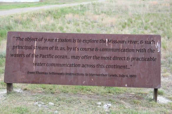


 As you leave the Missouri Headwaters State Park access road (Montana 286) and return south to old U.S. Highway 10, you encounter a plaintive sign hoping to attract the thousands of heritage tourists who come to the state park–go a bit farther south and west and find the town of Three Forks.
 The story of Three Forks, on the western edge of Gallatin County, is not of rivers but of railroads, of how both the Northern Pacific and the Milwaukee Road corridors shaped this part of the state at the end of the first decade of the 20th century.


 Continuing west you soon encounter post-World War II service stations and motels, some updated, some much like they were, on the outskirts of town and then, boom, you are in the heart of Livingston, facing the commanding presence of the Northern Pacific depot complex with warehouses–some now converted to new uses–coming first and then
 massive passenger station itself. Opened in 1902, the passenger station was an architectural marvel for the new state, designed by Reed and Stem, who would continue on to great fame as the architects of Grand Central Station in New York City. The station, interestingly, is not Classical Revival in style–certainly the choice of most architects for their grand gateways along the nation’s rail line–but a more restrained interpretation of Renaissance Revival style, completed in red brick.
 The building is not particularly inviting for locals coming from the business district to the depot–that was not its primary audience. Rather the grand entrance is track side, where passengers headed to Yellowstone National Park could depart for food, fun, frivolity, whatever they needed before the journey into the wildness of Yellowstone.
 Travelers were welcome to use the grand covered walkways to enter the depot proper, or to take a side visit to the railroad’s cafe, Martin’s as I
 knew it back in the day, a place that rarely slept and always had good pie. The cafe changed its orientation from the railroad to the road as automobile travelers on U.S. 10 began to dominate the tourist market. Now it has been restored as a local brew pub.
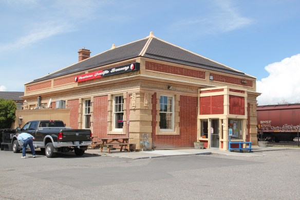


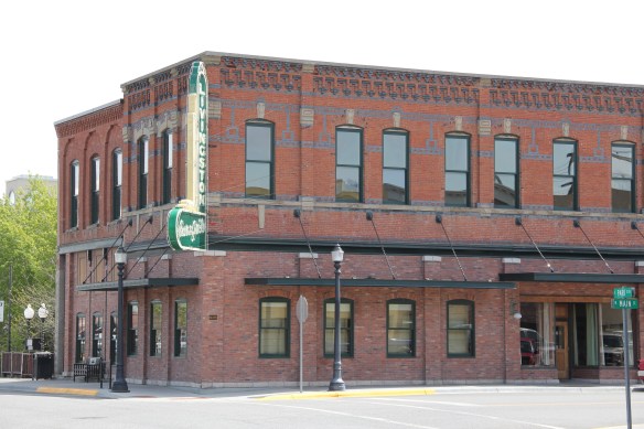 Directly facing the center of the passenger station was the mammoth Murray Hotel–a flea bag operation in the 1980s but now recently restored as a hipster place to be, especially its signature bar.

 Imagine my pleasant surprise last year when I found that Gil’s still existed but now had been converted into a decidedly up-scale establishment, far removed from the 1980s.
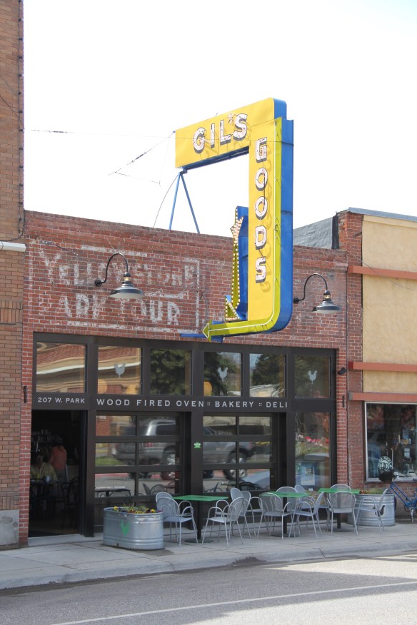 I don’t know if I have encountered a more fundamentally changed place–cheap trinkets gone, let the wood-fired pizzas come on.
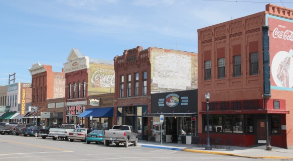 I was not so blinded in 1984 by the concept of the “metropolitan corridor” that I ignored the distinctive Victorian storefronts of Livingston–how could I since they all, in a way, fed into the tracks. But when I got to the end of that distinctive business district and watched the town, in my
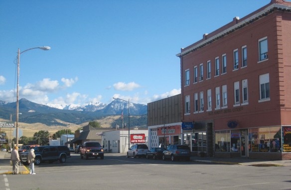 mind, fade into the Rockies, I had captured the obvious but had missed the bigger picture–that’s the next story.