Erasing the Great Northern Image across the Hi-Line

Image

Erasing the Great Northern Image across the Hi-Line

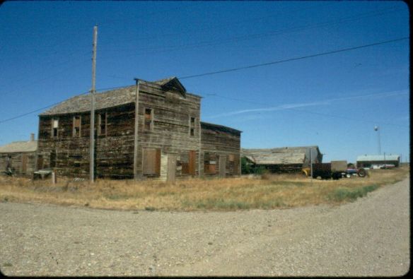
One of the most surprising–for me, even shocking–patterns in the 21st century Hi-Line landscape is how many railroad depots have disappeared from the small towns. Certainly major towns that provide access to the Amtrak passenger service (Havre, Malta, Glasgow, Shelby) still retain their historic buildings. But most others are gone. Certainly the corridor itself remains and the grain elevators still dominate the scene, reminding everyone of the power of agribusiness today, but the stations that told you here is a Great Northern town are not there. The photo is from Rudyard in Hill County where residents took the station, moved it blocks away to the edge of the village, and use it now as a centerpiece for a community museum. In Kevin, Toole County, the depot was moved off the tracks (only slightly, it is still within view of the corridor) and made a Senior center. These places are now rare reminders of the Great Northern’s imprint on the landscape through the means of their standardized design, painted white, passenger stations.

Phillips County Courthouse

Image

20130525-221217.jpg

Here is another building I mentioned earlier this spring, wondering about what happened in the 25 years since I was last in Malta. The courthouse has not been past over for a new building. It is in good shape but you wish they had not added the vines. If unchecked the vines will soon cover the facade and they will eat away on the brick. The real casualty in Malta is the former Carnegie Library, now abandoned and wilting away. Losing that fine neoclassical building will leave a big hole in the town’s heritage fabric.

Ghost towns on Montana’s Soo Line Corridor

Image

20130524-190859.jpg

I discovered years ago that few Montanans, not to mention Canadians, recognized that the Canada-based Soo Line had extended a spur into northeast Montana in the early 20th century. Some of the towns created in the wake of the railroad remain but most are gone, marked as a spot on the state map but really they are only towns in people’s memories. The state historic preservation office 20 years ago placed Comertown on the National Register. The next town west , Dooley (shown here) is another worthy candidate. In 2005 residents past (and present?) placed a large boulder to mark the town, etching buildings and dates for posterity. Or so they thought. The etchings are already going faint in the harsh wind blown plains. The church remains–but for how much longer?

South gateway to Yellowstone valley

Sheridan, WY doesn’t call itself the south gateway but I consider it to be that. Sheridan is a good 2 days of driving from Murfreesboro. And after a respite at the Mint Bar (one of the best places in the west) I enter Montana in the morning light and get to work, stopping briefly in Hardin (the first county seat of the fieldwork–let’s see how many I make). Then a mid morning meeting with the O’Donnell family before I strike east.

20130520-190226.jpg

20130520-190236.jpg

Lewis and Clark in Missouri

Today’s drive paralleled a portion of the Lewis and Clark Trail I had never visited. Now being a proud board member of the Lewis and Clark Trust, I needed to visit Arrow Rock, Missouri. Wish I had stopped before. A stunning town of mid 19th century buildings, together with the vistas of the river. A must stop on the trail.
Storms impeded afternoon fieldwork and the storm I avoided has now hit at Des Moines.

20130519-184117.jpg

20130519-184130.jpg

The trek to the Hi-Line starts Sunday

The trek to the Hi-Line starts Sunday

Here is my last pre-fieldwork post, an image from 2011 that reminds anyone of the starkness yet the grandeur of the Hi-Line Country landscape. Agricultural and oil mixed together on the horizon–this image may be from US 89 south of the Hi-Line but it represents a major contrast that characterizes the region–but the scale of the late 20th century wells pales in comparison to the landscape of fracking. The tension is there; can’t escape it. Yet those same two-lane roads beckon–and I am eager to be immersed into the vastness of it all once again. See you from the road, starting Sunday.

Listening at Camp Fortunate, 2012

Image

20130515-211917.jpg

So many of the blogs in the last 3 weeks have spoken of looking and seeing change over a generation. But just as important as close viewing is close listening. The voices of Montana sound different from those of my native Tennessean but I often heard similar tales: themes of community, family challenge, opportunities lost and gained, the heavy hand of power be it capital or the federal presence, and the stories of the deeper past, called intangible by some but oh so tangible to those who touch it, feel it daily. The landscape loses meaning without the voices. The voices are lost without the landscape.

Ghosts Towns along the Hi-Line

Image

Ghosts Towns along the Hi-Line

In 1984 I began my statewide fieldwork on the Hi-Line with Toole County being among the first stops. Here I encountered Devon, a town name that denotes rural beauty from Great Britain, but here along the Great Northern Railway and U.S. 2 it had become a forgotten place. I soon discovered that many other Devons existed in the region, and I talked about a good many of them in the “Travelers Companion to Montana History” book. Since that time, Don Baker has written “Ghost Towns of the Montana Prairie” that documents even more of these places. Three decades later, my basic question is: how many of these ghosts have now blown away leaving only scattered foundations behind? Those that remain are powerful physical documents of the Homesteading Era, which 100 years ago still held such hope and promise for the region.