
 U.S. Highway 2 enters northwest Montana in Lincoln County and from there the federal highway stretches eastward through the towns of Troy and Libby with vast rural stretches along the way to Kalispell. Paralleling the highway is the historic route of the Great Northern Railway, which brought timber and mining industries to this corner of Montana.
 Before you encounter the towns, however, there is a spot that is among my favorite in the state, and a place that I discussed in some depth in the book A Traveler’s Companion to Montana History: Kootenai Falls.

Kootenai Falls, 1984 image.
The river and the falls were a natural dividing line between the Upper and Lower Kootenai Indians. Both groups shared the falls and considered it sacred. David Thompson, the North West Company fur trader, visited the falls during own of his sojourns from Canada into northwest Montana in the early 19th century and left an early description. But in 1984 it took some dedication to gaze upon this most sacred and beautiful landscape. There was sort of a pull-off from the highway and then you meandered across the forest, carefully crossing the Great Northern tracks, to then find a good vantage point.


Today there is the 135-acre Kooteenai Falls Park, one of the best improvements in Montana’s heritage development over the last 30 years. Not only is access to the falls much safer but public interpretation explains the site’s vital importance to Native American peoples who were here long before the railroad, the logger, the miners, and the town builders.

 The falls is spectacular, no matter what time of the year you visit. But do stop and consider the mountains and bluffs that surround it. The entire landscape is what mattered to the Native Americans as they navigated through the area, or took vision quests at isolated places, or stopped to fish along the banks or hunt the wild game who also came to the falls for nourishment.
 There are few less untouched places than Kootenai Falls. The county park provides access and information. It is then up to you to explore, stop, and think about how humans have interacted with this places, taking aways thoughts and messages that we can only guess at, for thousands of years.
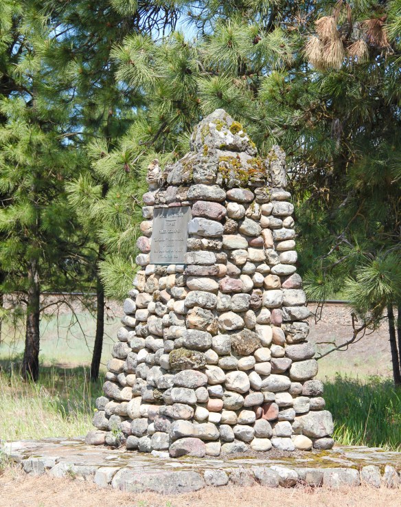 On the outskirts of town, the 1920s monument to David Thompson was the centerpiece of the town’s heritage tourism attractions in 1984-1985, now it is more of an afterthought. David Thompson was a Welsh-Canadian who established the first trading post in this river valley, called Saleesh House, for the tribe with whom this veteran of both the Hudson Bay Company and North West Company had targeted for the fur trade. His last visit to Saleesh House came in the winter of 1812. Thompson, I thought in 1984, was a very important figure in Montana history but increasingly a neglected trader–in fact most of the early traders, like those of the American Fur Company on the Missouri and Yellowstone Rivers, are neglected, even though significant places associated with them remain intact on the state’s landscape.
 About one hundred years after David Thompson’s last winter at Saleesh House, an entirely different landscape emerged along the Clark’s Fork River, one that introduced the recent technology of electricity to the region. To support and encourage the development of hydroelectric facilities, the city of Thompson Falls combined with investors to build what became known as the “High Bridge,” a way for automobile traffic to cross this gorge in the Clark’s Fork and unite settlement on both sides of the river.
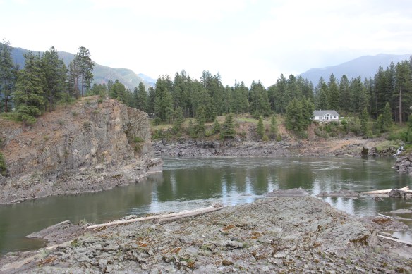 The High Bridge was an early 20th century Montana engineering marvel. It was 588 feet in length, designed for automobile traffic, with a 18-feet wide deck standing on a combination of Pratt and Parker trusses. It is the longest bridge of its kind in Montana.


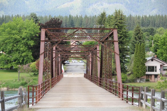 But within two years, residents and officials combined together to place the bridges and hydroelectric facilities in the National Register of Historic Places as a historic district. They were preserved, but still not used, for a generation.
 In 2009-2010, residents worked with local, state, and federal government officials to restore the bridge, add a pedestrian deck, and to open the bridge and either side of the bridge as a public park. Funding in part came from the American Recovery and Reinvestment Act of 2009, one of the ways that short-lived federal building effort benefited historic preservation in Montana small towns.
 The High Bridge experience not only reconnected Thompson Falls to its river roots, it also creates an unique experience for heritage travelers. The site is not that far different from 100 years ago, giving you the chance to cross a river and peer below but also to realize just how “wild” automobile traffic was in the 1910s and 1920s.