


Bozeman, the county seat of Gallatin County, was one of my favorite Montana towns during the 1984-1985 survey. In some ways, it was still a cowtown, a commercial center for the hundreds of surrounding ranches in Gallatin County. Yet it was also a college town–bars, music, cheap eats–as home to Montana State University. In 1980 its population was over 21,000–thirty years later by 2010 it had boomed to over 37,000. By the time I explored the town in 2015 for this new survey there were an estimated 42,000 residents, double of that of the 1980s town I had so enjoyed.


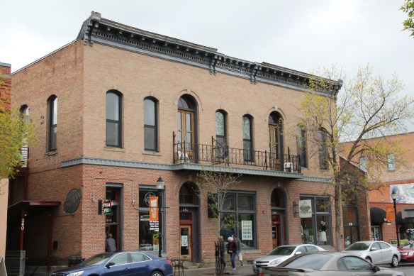
In 2007 then State Senator Lynda Bourque Moss stopped with me in Bozeman as we traveled from Billings to Helena where I was to speak to the governor’s task force on historic preservation, a meeting where the idea that I would recreate the survey of 1984-1985 first took root. We stopped because she wanted to show me changes. The four photos above showed me that yes, change had come, and in a big way to Bozeman. The old Hallmark Store, which had moved into an earlier Stockman Bar, had become an upscale wine bar–a bit of California in the old cowtown of Bozeman–and when I next returned “Plonk” had added sidewalk seating. We could have been in Aspen, at least Breckinridge, Colorado.

Plonk and the sporting goods store, 2007
Bozeman had eagerly embraced the idea of historic districts in 1984-1985 as a way of revitalizing its downtown–so much had moved, or was going to move, out to the interstate exits. John DeHaas at Montana State University had done so much to promote historic preservation in the 1970s and early 1980s. A tradition and commitment were in place. That much was clear when I surveyed the town and talked with residents and decision makers in 1984-85. The next several posts will explore the impact of those historic districts in the last 30 years, and offer observations on where next steps may go.
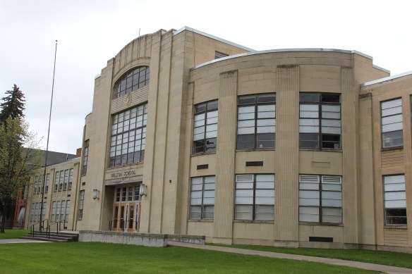


Let’s start with what I saw as the public landmarks, and anchors, for downtown Bozeman in 1984-1985. None was more important than the New Deal era Gallatin County High School, a striking Art Moderne design by Bozeman architect Fred Willson. At that time, the “new” high school–which stood right by an earlier 20th century brick high school building–was not “old enough” to be considered for the National Register. This building, like many of the state’s New Deal era legacy, has since been listed in the National Register. And its grounds have been re-energized for all who walk by through the installation of a statue in honor of Malcolm Story, designed by Belgrade, Montana, artist Jim Dolan and placed in front of the earlier high school in 1995.

Across Main Street is another public anchor, also funded by the New Deal in the late 1930s and also designed by Fred Willson: the Art Deco classicism of the Gallatin County Courthouse. Next door is the historic county jail, in a distinctive castellated Gothic style, which already had been converted into headquarters for the local historical society and county museum when I visited in 1984. The facility still serves that purpose today.


A couple of blocks away from this public landscape core of Bozeman were additional public buildings, on side streets to Main Street. Tracy and Babcock Streets had the town’s first two federal buildings/post office. The 1915 neoclassical styled post office operated until 1964 and filled several community roles, including a turn in the 1990s hit movie A River Runs Through It until it became home to the non-profit HRDC after a complete renovation at the turn of the 21st century. The building also has been enlivened by the addition of Jim Dolan’s statue in honor of Jeanette Ranklin, the first woman U.S. Congress representative, elected in 2010 from Montana.


Nearby is the mid-1960s Federal Building, a grand though boxy five-story building that symbolized the growth of the federal government and its impact on Gallatin County in the Cold War era while also adding a modernist design landmark to the city’s mix of Victorian and Classical architectural styles. The earlier post office was given attention in my 1984-85; due to its date of construction and style, I paid no attention to the new Federal Building. I didn’t repeat that mistake in 2015–the Federal Building of 1964-66 is one of the region’s most impressive statements of Montana modernism. and a much more recent Federal Building, which I ignored, for reasons of chronology that no longer apply in 2015.


The final public anchor was the Carnegie Library of 1902-1903, one of the better architectural expressions of Classical Revival style in the state, designed by architect Charles S. Haire, who shaped so much of state’s architecture in the early 20th century.
 Then Senator Moss took me for a quick tour of its late 1990s renovation in 2007–its conversion into law offices respected both its original spaces and interior design.


That brings me to the four commercial anchors you encountered on Main Street in 1984-1985. Two were massive buildings on either end of Main Street that defined the entire district–the Renaissance Revival style of Hotel Baxter, individually listed in the National Register in 1984, and the massiveness of the Victorian Romanesque style of The Bozeman Block, reminding everyone of the town’s railroad era.


In the middle of the district were two other key National Register properties–the Ellen Theatre, a wonderful Beaux Arts design scaled for the small town that it served in the 1920s. Everyone thought that keeping a movie house/ theater downtown would help keep it alive at night. The second building, the Union Hall, was both historically important but also could serve as a symbol of what downtown revitalization meant–a building need not
be spectacular to serve an important role in the historic district. The c. 1880s building belonged to the town’s boom during after the Northern Pacific Railroad arrived, and originally served as a brewery. Here was where the Bozeman historic preservation office was located when I conducted the state historic preservation plan survey in 1984-85. Next let’s consider the town’s railroad resources, a focal point of mine 30 years ago.


 The district’s architectural jewel, the Dining Room, dates almost a generation later to 1926. Architect Gilbert S. Underwood designed one of the late marvels of the Rustic style as defined in the northern Rockies. With its rugged stone exterior rising as it was a natural formation in the land, the dining room immediately told arriving visitors that an adventure awaited them, especially once they stepped inside and experienced the vast log interior spaces.


 Other former Union Pacific buildings have been given adaptive reuse treatment by the town, with a baggage building becoming police headquarters and the former men’s dormitory has been converted into a local health clinic.

 Thus, West Yellowstone is among Montana’s best examples of roadside architecture as distinctive 19502-1960w motels and a wide assortment of commercial types line both U.S. 191 but also the side arteries to the highway.


 I used a slide taken in 1982 in all of my public presentations about the Montana state historic preservation plan back in 1984-1985. I found out that few Montanans knew of the place and its history. What has changed since the 1980s? The park is still little known and receives infrequent visitors. In my 2015 fieldwork, I saw signs of new heritage development–the park sign, a bit of improvement to the outdoor interpretive center, and new interpretive exhibits with a more inclusive public interpretation and strong Native American focus.


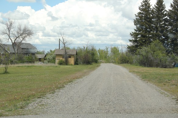
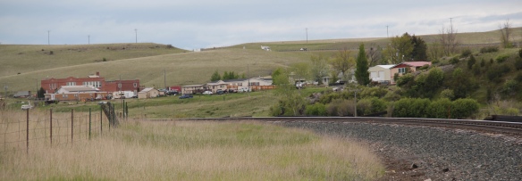
 Willow Creek was the end of the line for both the Northern Pacific and Milwaukee Road railroads as they vied for dominance in turn of the 20th century western Gallatin County. The Northern Pacific came first with its spur line to Butte in the late 1880s then the Milwaukee arrived c. 1908. Both used the same corridor, along what is now called the Old Yellowstone Trail on some maps; the Willow Creek Road (MT 287) on others. It was a route that dated to 1864–the town cemetery, according to lore, dates to that year and Willow Creek has had a post office since 1867.


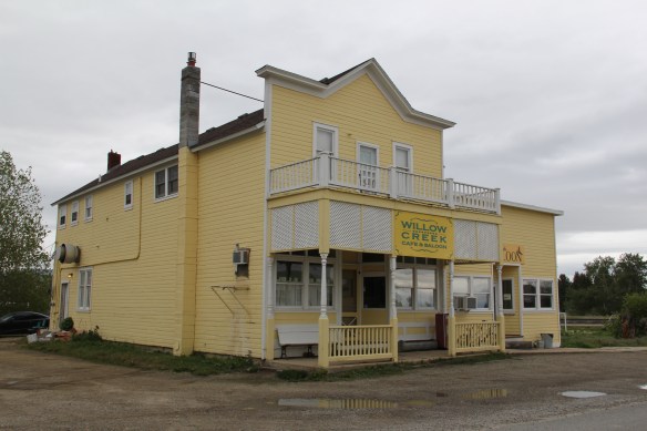 Across the street is the “employment center,” the Willow Creek Tool and Technology which sells its wares across the west out of its brick building from the 1910s. (Note the faded advertising sign that once greeted travelers on the Yellowstone Trail highway.)
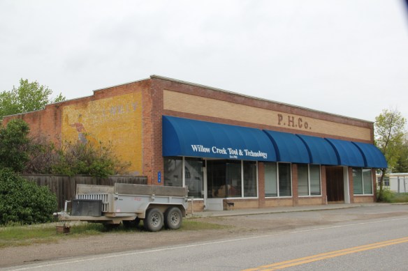 The cultural side of Willow Creek is represented by several places: homes and galleries of different artists, a monthly arts festival in the summer, and two special buildings from the 1910s. The Stateler Memorial Methodist Church, c. 1915, is listed in the National Register of Historic Places. Built from rusticated concrete blocks (from the cement factory at Three Forks) designed to resemble stone masonry, the church building is home to one of the oldest congregations (1864) in the Methodist Church in Montana. The Gothic Revival-styled sanctuary is named in honor of its founding minister Learner B. Stateler.
 Nearby is another crucial landmark for any rural Montana community–the local school. The Willow Creek School is an excellent example of the standardized, somewhat Craftsman-styled designs used for rural Montana schools in the 1910s. Two stories of classrooms, sitting on a full basement, was a large school for its time, another reflection of the hopes of the homesteading era.
 Additions in form of a gym and added rooms had come to the north and the school and its lot is the town’s community center. Although so close to Three Forks, the school kept its


 Three Forks, Montana, is unique in how competing railroads shaped this one small town between the 2008 and 2010. The last post discussed how the Milwaukee Road came first, and its landmark Sacajawea Inn stands at the north end of the town’s main street. On the east side–see the Google Map below–became the domain of the Northern Pacific Railroad and its spur line to the copper kingdom of Butte
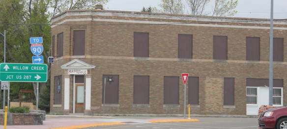


 Company. In 1914 Charles Botcher bought the plant, renamed it the Ideal Cement Company and kept it in business under that name until the 1980s.


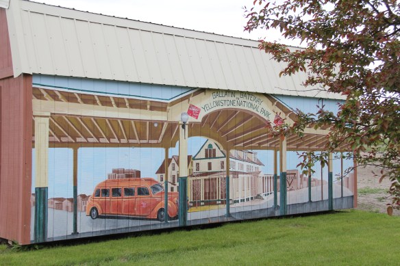
 As you leave the Missouri Headwaters State Park access road (Montana 286) and return south to old U.S. Highway 10, you encounter a plaintive sign hoping to attract the thousands of heritage tourists who come to the state park–go a bit farther south and west and find the town of Three Forks.
 The story of Three Forks, on the western edge of Gallatin County, is not of rivers but of railroads, of how both the Northern Pacific and the Milwaukee Road corridors shaped this part of the state at the end of the first decade of the 20th century.


 Located between the Gallatin River and Interstate I-90, Logan is a forgotten yet still historically significant railroad junction on the Northern Pacific Railroad. Established c.


 Manhattan was not originally Manhattan, but named Moreland, as discussed in an earlier blog about the effort to build a barley empire in this part of Gallatin County at the turn of the century by the Manhattan Malting Company and its industrial works here and in Bozeman. But the existing railroad corridor, along with the surviving one- and two-


 The historic auto garage from c. 1920 above is one of the most significant landmarks left upon old U.S. 10, and I am glad it is still used for its original function in the 21st century.


 But it has many positives in place to keep its character yet change with the times. Many residents are using historic buildings for their businesses and trades. Others are clearly committed to the historic residential area–you can’t help but be impressed by the town’s well-kept historic homes and well-maintained yards and public areas.


 From 1983-85 Belgrade became one of my favorite Northern Pacific railroad towns. Often I would leave the interstate here, stop at truly one of the great small town bars/cafes along the town’s railroad corridors, and then travel on old U.S. 10 (the town’s Main Street) on to Manhattan, Logan, and Three Forks before popping up on US 287 and continuing to home in Helena.
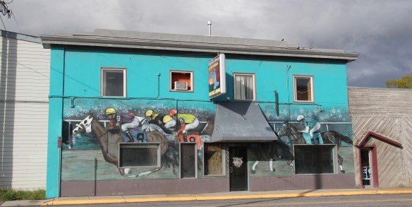

 Despite the boom, several landmarks remain. The Belgrade Community Church, built in 1904 as the town’s Presbyterian church, served in the 1980s as a joint church building for both the town’s Presbyterians and Baptists. This impressive Gothic Revival building had received several updates and additions in the mid-1970s. It became the Community Church in 1992 as the Presbyterians left and the American Baptist Church took over sole control of this historic church building.


