Riverside Cemetery, Fort Benton

Riverside Cemetery dates to 1883, a time of considerable change and expansion in Fort Benton’s history. Just 2 years earlier, summer 1881, the U.S. Army left the fort, and it began a rapid decline. In the following winter of 1881-1882 the town began a building boom that led to the construction of the Grand Union Hotel by the end of 1882.

Grand Union Hotel

Freight traffic on the Missouri River also boomed and the River Press, the city’s leading newspaper for the next 100 plus years, published its first edition. 1882 also witnessed the city’s first electric lights and the construction of many new residences. And by the year resident had formed the Riverside Cemetery Association.

Gate to Riverside Cemetery

The loss of the Chouteau County Courthouse to fire in early 1883 didn’t seem to slow momentum at all. That spring voters incorporated Fort Benton—what had been a trading and military town was now a formally established town. Soon thereafter Riverside Cemetery was established on the Missouri River bluffs northeast of town.

The new town cemetery had approximately 40 fenced acres and was ready for use by Decoration Day (now known as Memorial Day) in 1883. The cemetery also had reinterred graves from earlier in-town cemeteries at approximately the location of First Christian Church and behind Haas and Associates and Farmers Union Oil Company.

Today the gap between the initial cemetery and burials in the 20th century is noticeable. The early burials are on the east side while the modern section is on the east side clustered near a row of trees m. Clearly early tombstones have been lost—the number of grave depressions indicate that there are many additional burials that lack a grave marker.

East side of cemetery
Central section with the west section in the background among the trees. In general the west section dates to mid 20th century and later

The remaining grave markers from the late 19th century tell powerful stories. The Charles Fish (d. 1890) obelisk with urn marker below honored a Canadian native who served as a drummer boy with the 38th Wisconsin Infantry in the Civil War; he was only 15 years old when he joined.

The Patterson family section is one of the cemetery’s oldest, with the earliest tombstone dating to 1886.

Tombstones with cross themes mark the graves of Jane Jackson (d. 1885) and Edward Kelly (d. 1890).

This image of the Jackson tombstone is another visual example of the number of empty spaces in the east side of the cemetery. Existing depressions indicate that many burials without grave markers are in the section.

In 1891 the cemetery received its first U.S. military veterans markers. The one below was for Patrik (the spelling used on the tombstone) Fallon, a Civil War veteran. By now Fort Benton had grown to the point that its Decoration Day ceremony involved hundreds, led by the cemetery association, camps of the Grand Army of the Republic and soldiers from Fort Assiniboine.

While the graves of many pioneers are unmarked, the Sullivan family located its graves near the edge of the bluff, truly an awe-inspiring setting overlooking the town, river, and railroad tracks.

Impressive tombstone art is scattered throughout the cemetery. The unique yet beautiful pressed metal crosses for brothers Julius (d. 1923) and Henry (d. 1924) Bogner belong, stylistically to the Victorian era, but were commissioned and installed in the Jazz Age.

Julius and Henry Bogner
The Winfred and Margaret Stocking marker (c. 1910-12) is unusual in that a sizable base supports a triangular rock Boulder. Margaret Stocking upon her death in 1812 was identified as the first white woman to settle in Fort Benton in 1865.
The marker for Bessie Bright (d. 1917) has an open Bible motif, typically found in tombstones of the 19th century

Riverside Cemetery has an impressive veterans section, known as the Military Plot. Veterans from the Spanish American War of the 1890s to the conflicts of the 21st century are buried here.

The majestic flag pole was added in 2916.

Kenilworth Hall in Choteau County

Kenilworth Hall 1984

I first visited Kenilworth Hall, on Montana 432 west of Big Sandy, early in my 1984 fieldwork for the Montana state historic preservation plan. At the time I really hadn’t seen enough, or heard enough, to understand the overwhelming significance of these rural places. What caught my eye was the building itself—like the top half of a barn plopped down at an empty crossroads in the middle of nowhere. Its very presence told me it had to be important.

And as I held public meetings and stopped in at local museums that winter into the spring, I learned that community halls were very important gathering places for ranch families. At Kenilworth, there were parties for all the seasons. Various clubs met regularly. It was a social and educational hub.

So last month I purposely took the drive to see if Kenilworth Hall was still there. I half expected it would be gone. But it was there, barely as the images below attest.

The hall needs some TLC, and a paint job. And it should be recognized as an important place. I hope it has a second wind—or third and forth, and remains a west Chouteau County landmark for decades to come.

Decision Point on the Missouri River

Confluence of Marias and Missouri Rivers

In my 1984 field study for the Montana state historic preservation plan, there were many places that were “known” to Native American tribal historians, students of the Lewis and Clark expedition, and scholars of the northern plains fur trade. But few of these places were provided public interpretation. much less public access. Such was the case with the Lewis and Clark campsite of early June 1805 at the confluence of the Missouri and Marias River.

Location of Lewis and Clark Expedition campsite

The campsite became known as decision point because as the expedition rested and regrouped there, they also decided which river to follow. After initial investigations, the members chose correctly and soon found themselves at the great falls of the Missouri River.

When I carried out my 1984 work, everyone knew that the confluence was at Loma, seen in the background of the photograph above. But access to the actual location and significant public interpretation was still to come. As I have written in numerous prior posts, one of the most significant changes from 1984-1985 and my recent work in Montana from 2012 to 2021 is the amount and quality of public interpretation and public access to significant historical landscapes. There has been a huge improvement, and Decision Point is an excellent example of federal agencies working with landowners and state and local government as part of the Upper Missouri River Breaks project.

The image above tells the story of the steamboat Ophir and the amount of river trade that once marked the Missouri River. The interpretive marker below tells the story of the early American Fur Company trading post known as Fort Piegan.

Fort Piegan site

Even if you are not into the history of the region, the overlook created and maintained by the Upper Missouri River Breaks National Monument is a beautiful vista, and conveys strongly the landscape as encountered by generations of Native Americans and then in much more rapid succession by the Lewis and Clark expedition, American and Canadian fur traders, steamboat travelers, and by the 1880s the tracks of the Great Northern Railroad. An absolutely stunning historic site.

Fort Benton and the National Stage

img_8791

In February 1984 one of my first assignments on the grand field study of Montana known as the state historic preservation plan survey was to check on the progress of the restoration and reopening of the Grand Union Hotel in Fort Benton.

Chouteau Co Ft Benton Grand Union Hotel 4

Chouteau Co Ft Benton Grand Union Hotel 1The work was still underway then, but the result after 30 years of local investment and engagement, assisted mightily by the state historic preservation office and other state groups, is impressive.  The Grand Union is a riverfront anchor on one of the nation’s most important river towns in all of U.S. history.

Chouteau Co Ft Benton Old Bridge 9The success of the Grand Union is mirrored in another property I visited in my 1984 day and a half in Fort Benton:  the reconstructed Fort Benton.  There were bits of the adobe blockhouse and walls still standing in 1984, as they had for decades as shown in the old postcard below.

Unknown

What the locally administered Museum of the Upper Missouri managed to do was to protect a vitally important site of national significance, and then through its own museum exhibits, try to convey the significance of the place to those who happened to discover it.

Chouteau Co Ft Benton Front St museum

In the past 30 years, the museum and its supporters managed to continue protecting the archaeological remnants of the fort but also to rebuild the fort to its mid-19th century appearance.  This reconstruction is no small feat, and naturally requires staffing, commitment, and monies to keep the buildings and exhibits in good condition.

Chouteau Co Ft Benton old fort  and buffalo robe press


Chouteau Co Ft Benton old fort 19


A few steps away is another preserved historic building, the I. G. Baker House, built for one of the town’s leading merchants and traders, in weatherboard-disguised abode, in the traditional central hall plan of the mid-19th century.  For decades, it has been a passive historic site, opened to the public, with rooms and collections protected by plexiglass.  You already have to know much to appreciate the jewel this early bit of domestic architecture represents in understanding the building traditions of the territorial era.

Chouteau Co Ft Benton Front St Baker House

These successful heritage development of the hotel, the fort, and the preservation of the I.G. Baker House, however, has not spurred a greater recognition of the significance of Fort Benton to either national audiences or even residents of the Big Sky Country. When I mention Fort Benton here in the east I typically get blank stares or a quick change of topic.  But the town was the westernmost port on the Missouri River, the first interstate exit if you will into the northern plains and northwest.  From Fort Benton ran trails and roads into western Canada, Washington State, and into the mines of the Rocky Mountains.  The building of the Manitoba Road in the late 1980s eventually meant the town’s importance as a river port was bypassed, but from the mid-19th century into the 1880s, Fort Benton was THE place for commercial expansion, riverboat travel, economic exchange, and the deeper cultural exchanges of the fur trade, with all of those events shaping the national economy and culture.  How can such a legacy become diminished? Why? Is it the central Montana location?  The lack of national folklore heroes?

Chouteau Co Ft Benton Choteau Hotel 1

Chouteau Co Ft Benton Front St 35

Chouteau Co Ft Benton Front St 4

Fort Benton is doubly valuable because it is a town with layers, as I have discussed in earlier postings.  The town, unlike many of Montana’s early settlements, was no ghost town, instead it was a town with its frontier river port layer, its territorial layer, and its homestead boom layer all competing for attention. The past lives side to side with the present in Fort Benton and thus, it has the potential to shape the future of the town, and this region, in ways that cannot be replicated elsewhere.

Chouteau Co Ft Benton Front St 2

Now it is time to stress to our national representatives that it is time for America to cast its eyes, and its support, for the preservation and heritage enhancement of a place that tells so much of the nation’s story.  Here at Fort Benton is a living historic town, a place where you can stay a bit and learn how the country has grown, changed, and together can better face our uncertain futures. The residents have made a lasting commitment–it is now time for Fort Benton to reach the national stage.

Chouteau Co Ft Benton Front St 40


Chouteau County’s Plains Country Towns

IMG_9327

Thirty years ago geographer John Hudson wrote a series of articles and a book on the topic of “plains country towns,” addressing the landscape patterns he found among the railroad-established towns of the northern plains.  Ever since Hudson’s concept of plains country towns has influenced how I look at the Montana’s small towns.  Even in such river counties as Chouteau County where the Missouri River trade base of Fort Benton has dominated the county’s economy and population since the mid-19th century, you can still find the unmistakeable imprint of the railroad and the grain elevators that mark the presence of a town.

IMG_8832

Earlier in this blog I have discussed Square Butte (above) and Geraldine.  Today I want to review two other small towns, Highwood and Carter.  Highwood is the largest, counting

IMG_8873

just about 175 people in the last census.  Like most plains country towns, it has steadily lost population in the last 50 years.  In fact this weekend’s Great Falls Tribune discussed how the Highwood High School was going to forge a co-op for sports with Geraldine so both schools could continue to have basketball, volley ball and 7-man football, played at this tiny field in Highwood.

IMG_8875

IMG_8877

The Highwood School is no doubt the pride and center of this community, a place not often found by travelers nestled as it is in a gulch formed by Highwood Creek along Montana Highway 228.  It began in the 1880s as cattle country but with the coming of the railroad in the 1910s t became an outlet for grains, as its set of tall elevators makes apparent.  A small one-story false front building for the 1912 Highwood Mercantile Company also remains to mark the town’s railroad years.

IMG_8881

IMG_8880

Carter has one-third the population of Highwood–only about 50 people in the 2010 census–but is better known to travelers due to its location along U.S. Highway 87 between Great Falls and Fort Benton.  The Rocking K Bar is the roadside landmark but travelers

IMG_9334should turn south and drive down into Carter proper since the town, despite its tiny number of residents, still has many of the community institutions that defined a proper plains country town of 100 years ago.

IMG_9318

First, there is the still operating Carter Elementary School, probably the one institution that keeps the town alive–when country towns lose their school soon everything else goes too.

IMG_9319

Next comes the tracks, railroad depot, and the grain elevators–while not public institutions they do give the community commercial lifeblood, and as long as the trains roll by there remains an economic reason for Carter to exist.

IMG_9326

The depot has been moved from its original location paralleling the tracks, but this early 20th century standardized designed combination depot for the Great Northern Railway still stands–there were hundreds across the state in my survey of 1984-1985 and one of the more disturbing trends of the new survey of 2013-2015 is how many Great Northern depots are gone, eliminating from the landscape they once dominated.

IMG_9325

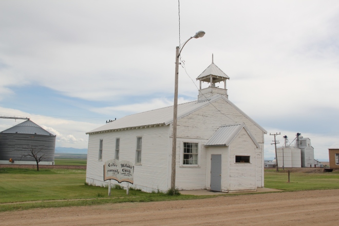
Faith too has remained in Carter, with the persistence of the town’s small vernacular styled gable-front little white Methodist church, although in its first generation several congregations had been established here.

IMG_9329

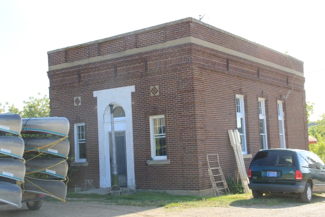
Carter also still has its Community Hall–an institution across the northern plains that defined hope and persistence in the years following the homesteading bust of the 1920s.
IMG_9331
Community halls too were more numerous in 1984-1985 than today–the building in Carter is a significant community link between past and present.

IMG_9330Finally there is the federal presence–marked by a concrete block post office from the last decades of the 20th century.  The threat a few years ago to close hundreds of rural post offices across the region brought new, and necessary, addition to role of post offices as modern community landmarks for plains country towns.

Admittedly, Carter is a place that hundreds roar pass daily as they drive U.S. Highway 87. But with its extant school, depot, brace of elevators, church, community hall, and post office, Carter is a valuable physical document of the plains country towns that once populated eastern Montana, serving as important way stations along the metropolitan corridors of rails and sidings that crisscrossed the west.

Geraldine: A Milwaukee Road Town that made it

IMG_8825

My last post looked at the disappearing towns of the Milwaukee Road in central Montana’s Meagher County.  Those themes of a railroad, town creation, and abandonment were constant in several posts as I traced the imprint  of the Milwaukee on Montana’s landscape in the 20th century.  However, not all central Montana plains towns tied to the Milwaukee Road have disappeared–Geraldine in Chouteau County is one of those exceptions.

Geraldine MR Depot Choteau Co

Milwaukee Road depot at Geraldine, c. 1998

Geraldine was established c. 1913 along a major spur line of the Milwaukee Road that connected its division point at Harlowtown to the much larger railroad transportation center of Great Falls to the north.  Due to the richness of the high plains agriculture of southern Chouteau County–the land south of the Missouri River–and the commitment of its citizens, Geraldine has remained generally solid through the decades.  According to census records, the town has never topped 400 residents, 375 being the largest number of residents, and now, according to the 2010 count, there are only about 100 less, a little over 260 residents.  Losing what amounts to 25-30% of the population over the 100 years sounds like a disappearing town, true, but in an eastern Montana perspective, it is not.  As this blog has documented at many places, too many plains country towns have lost 50% or more of their population in just the last 30 years.

IMG_8822

In the 1984-85 historic preservation survey, Geraldine impressed me for several reasons.  First was the dominating presence of the grain elevators, as seen above and with the first photo in this blog.  I had grown accustomed to Milwaukee Road towns where the corporate standardized design for the combination depot–a building that joined both freight and passenger operations–dominated the railroad corridor.  Here the elevators punctuate the skyline and loom over the town itself–the railroad created the need for them, certainly, but by the end of the 20th century the elevators were still viable businesses while the depot had become a local museum and community center.

IMG_8808

Then there was the town plan.  Milwaukee Road country towns were “T-plan” towns where the tracks, depot, and elevators defined the top of the T while the town’s business district formed the stem of the T.  Geraldine was a bit different, a tilted T-plan town, where the top

IMG_8818of the T, due to the railroad’s approach was slanted, giving Geraldine, compared to other Milwaukee towns, an off-kilter look.  Geraldine also still had business, although the number of independent places had diminished since 1984-1985.  Two key institutions today are

IMG_8817

the local state bank, a Classical Revival-styled two-story building from c. 1914 that is listed in the National Register of Historic Places as the First National Bank of Geraldine.  Unlike scores of other local institutions in the 1920s and 1930s, the Geraldine bank did not close its doors and continues to serve ranchers and town residents today.  It is a rock from Geraldine’s past that surely helps to define its future.  The same can be said for the

IMG_8823

Geraldine school–home of the Tigers.  This local school has several different building periods, as this image of its facade indicates, but maintaining a school district is vital to the town–plains country towns that lose their schools soon become abandoned places.

IMG_8815

Geraldine touches upon many key theme of eastern Montana history–in subtle yet significant ways.  It even lightly touches on another theme of this blog–Montana Modernism.  No one was much looking at the contemporary styled buildings of the late 1950s and 1960s in 1984-1985.  I was no exception.  But in the 21st century, we want to document those buildings and appreciate how the new architecture expressed the hopes of the post World War II generation.  Geraldine’s contribution is its United Methodist

IMG_8816

Church, with its particularly notable tall concrete bell tower, mixing a bit of tradition with the new look of the postwar generation.

IMG_8820

Geraldine of course has a classic western watering hole–Rusty’s Bar and Grill, completed with its front glass block windows.  It is highly recommended–not much on the outside admittedly but a full community experience on the inside.  Historic depot and bank, modern-styled church, unique town plan, and great bar:  more than enough reasons to come to Geraldine, not once but whenever travels take you between Great Falls and the Musselshell River Valley.

Fort Benton’s heritage development, part 2

Image

Lobby, Grand Union Hotel, 2013

In 1984, when John Lepley took me through Fort Benton and spoke of the community’s dreams for both preservation and heritage tourism, the vision was compelling but at the same time you had to wonder whether it was feasible.  One morning was spent at the Grand Union Hotel, a marvelous Victorian-era building, right on the river front.  It was then under restoration yet I had spent a night there and the future seemed bright.  But managing heritage assets is challenging and the hotel has passed through several approaches until its most recent owners seem got it right.  In the summer season and on weekend the hotel is a busy place.

IMG_8787

Next Lepley took me to the ruins of Fort Benton and spoke of the pending reconstruction of the fort.  The notion of reconstructing the nationally significant fur trade posts of the mid-19th century was an idea I had heard elsewhere, especially at Fort Union, at the confluence of the Yellowstone and Missouri rivers on the Montana-North Dakota border.

IMG_7404

But Ft Union would be a National Park Service project, with all of that agency prestige and federal funding behind it.  Fort Benton too was nationally significant but the property was not owned by the federal government–a complete reconstruction struck me as ambitious if not fantasy in 1984.  Well, I was wrong:  Fort Benton, mid-19th century, has been reconstructed, and serves as a centerpiece of the town’s public interpretation.

IMG_8719

The fort is not only rebuilt in its exterior–a reconstruction that you can find elsewhere in the West–but it has a completed interior, divided into period rooms and modern exhibit spaces.  Finally there is a property in central Montana that conveys visually and physically what a mid-1800s trading post was like, and just how crucial this mix of private enterprise and Native American relations was to the region’s history.

IMG_8741

IMG_8721

The reconstruction also preserves and interprets the few bits of original fort wall that exist–and that were slowly ebbing away back in 1984.

IMG_8726


No doubt the reconstruction of Fort Benton, and the preservation of the remaining fort site, are major achievements for anyone, especially a town and county that are relatively isolated from large population areas like this one.  In 1984, John Lepley shared with me one last set of resources–the riverfront buildings.  There the story still needs to grow.  The recent success of the hotel should spur even more investment into the adaptive reuse of these buildings. Splendid properties they are, and still a potential backbone for the revitalization of the local economy.

IMG_8709

IMG_8687

The 1984 story ends here–and I must admit that the progress in heritage development is impressive.  But there is still the more recent history to digest, and that will be the next blog from Fort Benton.

Transformations in Fort Benton, part 1

Image


In the spring of 1984, there was no doubt that I would spend considerable time looking at the historic preservation issues at Fort Benton, a small county seat today but one of the most important places in all of the northern plains before the age of the railroad.  Here at this bend in the river, shown in a postcard I bought there in 1984, was basically the last stop for Missouri River boat traffic heading west.  The fort dated to the late fur trade era and as the rush for precious metals overtook Montana Territory in the 1860s and 1870s here developed a major trade and outfitting post, with roads running from Fort Benton in all directions.  But the place was a sleepy, almost forgotten town, as the railroads changed routes and the interstates bypassed it by miles and miles.  Landmarks too were there but the old fort had been slowly coming apart, only a recent determined effort by save what remained and then, ambitiously I thought 30 years ago, to rebuild the lost fort and tell fully the story of the fur trade and the significance of the Upper Missouri.

Image  Image


My guide was John Lepley, who was spearheading the local efforts and a member of the SHPO board.  Another key leader was Joel Overholser. And no doubt, there was some heritage tourism and historic interpretation infrastructure in place.  The Chouteau House, a classic river hotel, was still open, rough on the edges but the place where I stayed and took meals. (It was closed when I visited last in 2013).

Image


Nearby was the home of I. G. Baker, a pivotal figure in the region’s history.  It was open, and paneled interpretation in place but certainly a property that could “say” more.

Image


Various monuments and markers could be found throughout the riverfront:  the Mullan Road, the Whoop-Up Trail, and especially the recently installed (1976) State of Montana Lewis and Clark Memorial, a monument piece of public art, sculpted by Bob Scriver with the base by Shorty Shope, another well regarded Montana artist.  The memorial was an American bicentennial project led by the Fort Benton Improvement Association, which Lepley and Overholser served on as commissioners.  Indeed, the state also had donated one of the keelboats used in the film “Far Horizons,” a Hollywood take on the Lewis and Clark expedition.  The waterfront told a story, one dominated by Lewis and Clark.

Image  

Image

postcard of Far Horizons boat, c. 1984

Image


The amount and quality of the public art along the riverfront was impressive, but what struck me as speaking most strongly to the town’s future were two completed projects (the Museum of the Upper Missouri and the Missouri River Bridge) and the almost completed restoration of the Grand Hotel, a remarkable Victorian building that spoke to the town’s hopes in the late 19th century.

Image Image


Image


I left Fort Benton convinced of two things:  the town had clear preservation needs, not just the fort site but buildings from the Victorian era were decaying too.  But compared to other places that I would visit in 1984, I thought Fort Benton had the one key trait for success–vision, the realization that the steps of the 1970s were just first steps, and many more needed to be taken in the years to come.  Let’s next come back to Fort Benton 30 years later and see how far that vision has reached.

ImageWho

Finding the Lewis and Clark story at Coal Banks Landing

Image

Coal Banks Landing, on the Missouri River in Chouteau County, was another site already recognized as significant when the preservation planning survey got underway in the spring of 1984.  Here was yet another documented place associated with the Lewis and Clark expedition:  it took its name literally from the band of lignite easily observed in the banks along the Missouri.

Image


The landscape here not only speaks to the age of river transportation; to the west at Virgelle you can also find the original roadbed of James J. Hill’s Manitoba Road as it came down from Havre and connected with the Missouri River valley, its route to Great Falls.  Virgelle has National Register-listed properties in its historic pressed tin-sided general store and brick bank; across the road are a school and grain elevator.  These properties marked the forgotten town as a place once prominent along the Great Northern network.

Image Image

Image Image

Coal Banks Landing, in comparison, was a place on the river, with little to tell its story.  Today, however, Coal Banks Landing is a prominent spot, with a modern boat landing, a seasonal interpretive center, and then year-round interpretive markers for its multiple layers of history.

Image Image


The landing and its significant Lewis and Clark story are now preserved as part of the Upper Missouri River Breaks National Monument, one of the state’s most important conservation and heritage tourism developments in the 21st century.  This national monument preserves not only one of the most breathtaking sections of the Lewis and Clark National Historic Trail it also preserves open land little changed from the centuries of occupation by various Native American groups and scattered often log-built homesteads of the multi-ethnic groups that flooded into northern Montana in the first two decades of the 20th century.

Image Image


Little was here in 1984 to help residents and visitors understand the deep significance of the Missouri River.  Today Coal Banks Landing is a must stop for any heritage tourist of northern Montana.


Lewis and Clark and finding the “true Missouri” at Loma, Montana

Image

During the early weeks of fieldwork in northern Montana in 1984, I certainly had notes and reminders to document sites associated with the Lewis and Clark expedition.  Here was one part of the region’s history that had been given its due by generations of historians, and the brown Pathfinder-themed markers of the Lewis and Clark Trail made the historic route one of the state’s most recognizable heritage assets.  Yet as I left Hill County and moved into Chouteau County, heading toward Fort Benton, there was little to mark the story along the Marias River and the decision that the expedition made regarding the “true” path westward–the Missouri River or the Marias River (the latter they had not expected to encounter).  There was a state highway marker at Loma, but that seemed not enough, considering the importance of the events on the Marias and the high integrity of this historic landscape.

Image


Opportunities not gained during the Lewis and Clark sesquicentennial in the 1950s were not missed during the bicentennial of the past decade.  As you approach the highlands above Loma, a major new interpretive kiosk not only presents a compelling view of the Marias landscape, it also interprets the significance of the location.

Image

Image Image


Here is an example of the partnerships now driving the interpretation of the Lewis and Clark Trail:  the Lewis and Clark National Historic Trail of the National Park Service being the most important, bringing a consistency of design and message to the interpretation.

Image 

With these partnerships, working with property owners, in place, visitors can experience such key sites as Decision Point, at the confluence of the Missouri and Marias rivers, where the expedition made the correct choice and followed the “true Missouri” westward.  Loma, rather than being a neglected place in the Lewis and Clark story, now has become a centerpiece of the region’s interpretation, thanks to new visions and new installations in the 21st century.

Image