The Warrior Trail of U.S. Highway 212

IMG_5457U.S. Highway 212, as it heads west out of the high prairies of southeast Montana, becomes known as the Warriors Trail, an appropriate description because the road provides various access points to some of the most important battlefields associated with the Great Sioux War of 1876-1877.  At Busby, immediately south of the highway, stands a monument and grave of one of the most prominent Northern Cheyenne warriors, Two Moons (1847-1917),

IMG_5472who fought in all three major battles (Rosebud, Little Big Horn, and Wolf Mountains) of the campaign in southeast Montana .  After surrendering at Fort Keogh in Miles City in April 1877, Two Moons joined the U.S. Army as a scout.  He later became a recognized reservation leader and made Busby his home; his monument along the highway became a landmark.  Since my last visit to the grave, a new security fence had been installed around the monument and nearby too were numerous other Cheyenne warriors, followers of Dull

Rosebud Co Busby Too Moons Grave 1 - Version 3Knife, who died in 1879 trying to escape confinement at Fort Robinson, Nebraska.  Their remains were kept in a museum until they were interred here in 1993, a result of the Native American Graves Protection and Repatriation Act of 1990.

Rosebud Battlefield 015
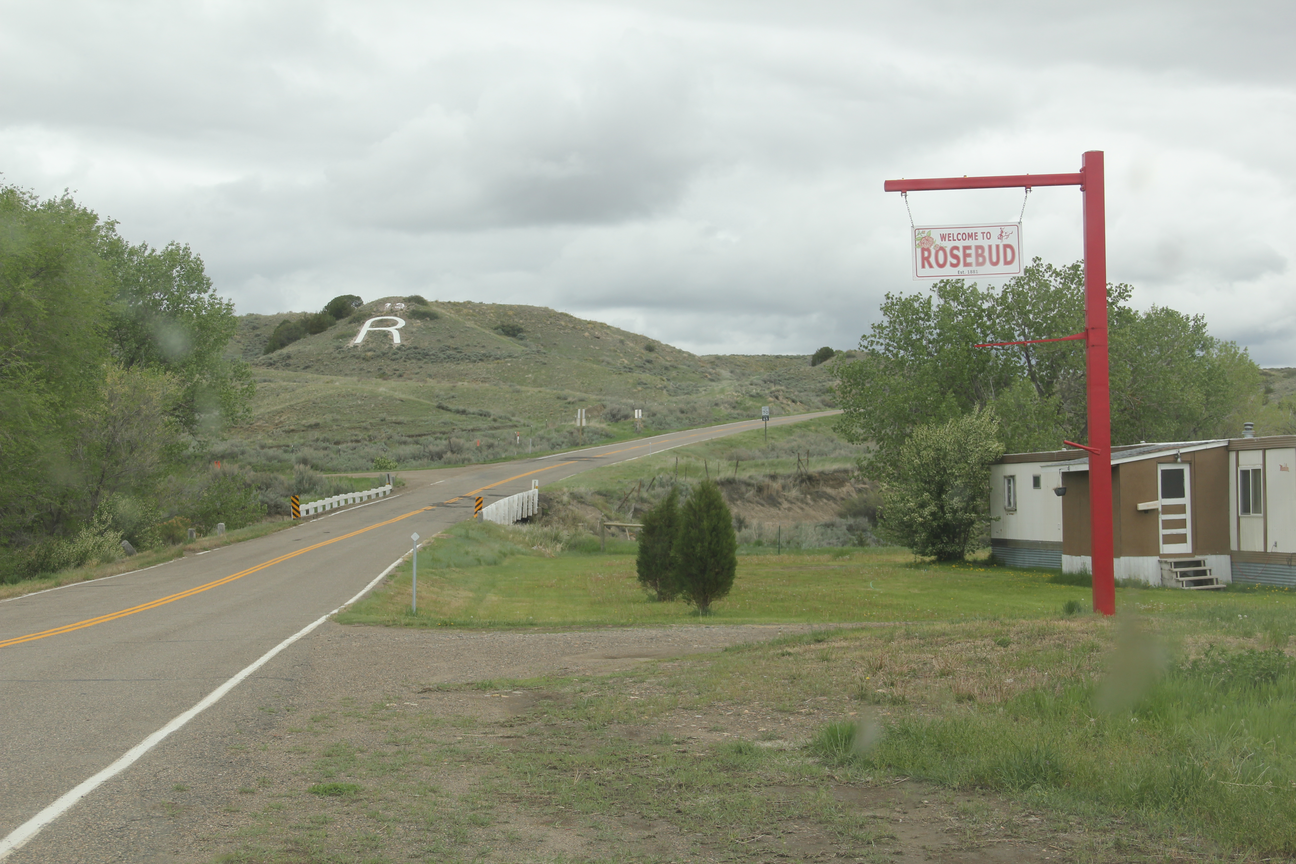
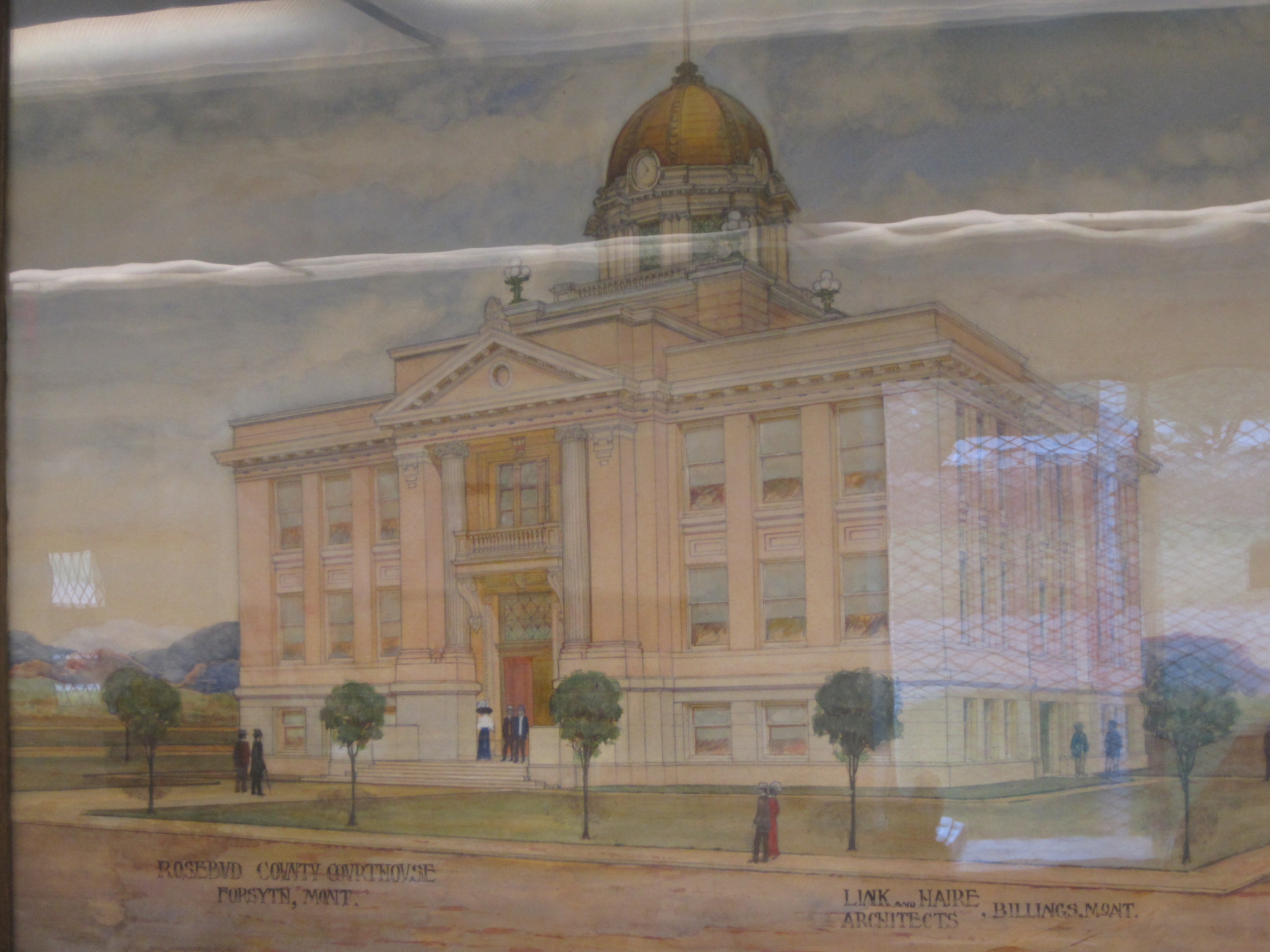
South of Busby is the Rosebud Battlefield State Park, a place barely on anyone’s radar (except for the Northern Cheyenne) when I carried out the 1984 fieldwork.  A local rancher had preserved the battlefield and donated some of its land to the state, and a basic park,

Rosebud Battlefield 021

Rosebud Battlefield 016

Interpretive markers in 2007 at Rosebud Battlefield.

with basic public interpretation, had been installed.  In the last ten years, however, due to threats from energy development in the area and the leadership of local ranchers, concerned Native Americans, tribal preservation officers, non-profit groups such as the Montana Preservation Alliance, land conservation groups, and the American Battlefield

Rosebud Battlefield 028Protection Program, and state parks, this important battlefield has been enhanced with new interpretation and a new commitment to protect the battlefield’s view sheds.  The battlefield commemorates the June 17, 1876 fight between U.S. Gen. George Crook and his Crow and Shoshoni Indian allies who were advancing up Rosebud Creek as part of a

Rosebud Battlefield 026
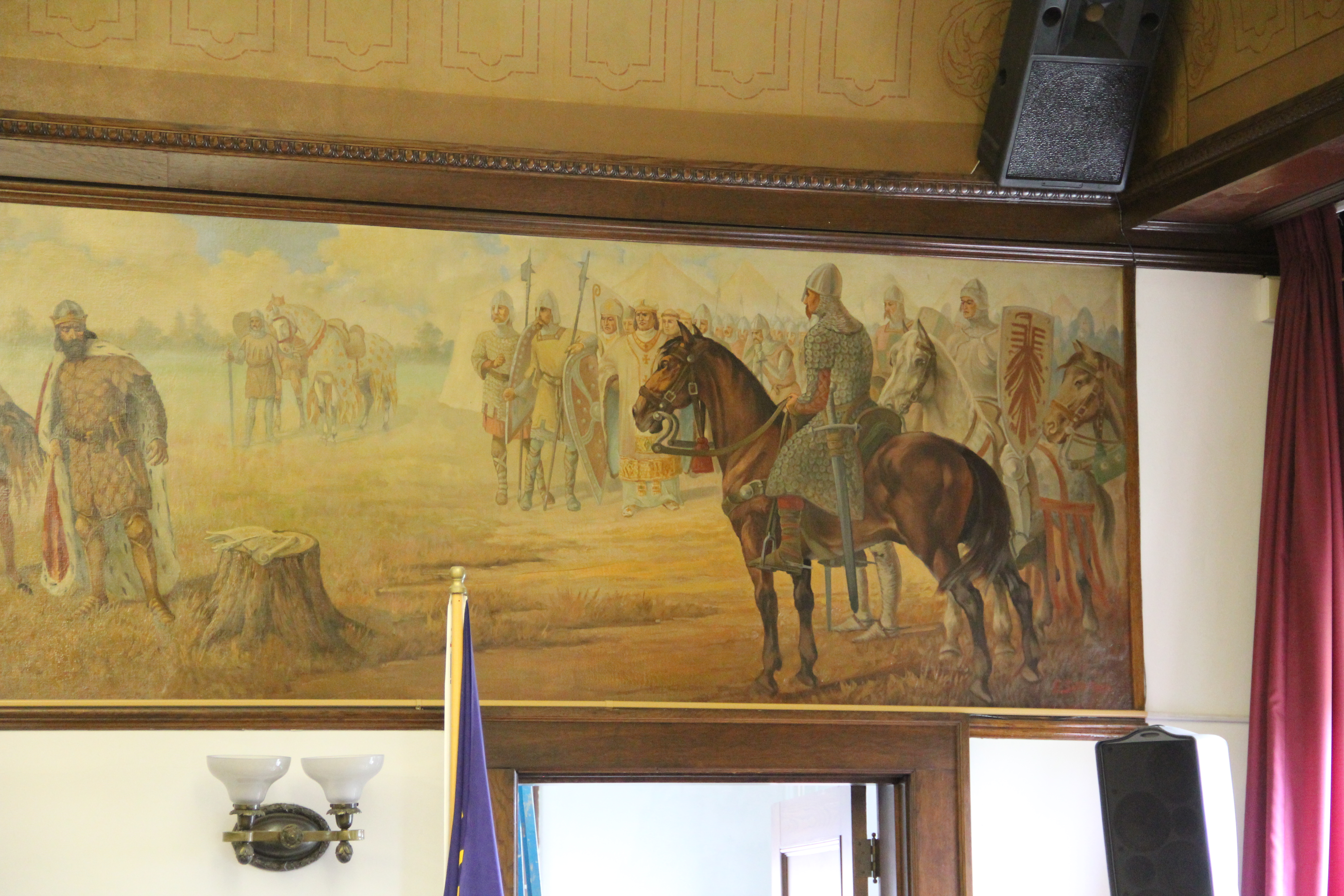
pincher movement to find and defeat a combined Lakota-Cheyenne force led by Crazy Horse.  The Lakota and Cheyenne carried the day and would have surprised Crook’s troops if not for their Native American allies.  Crook claimed victory but returned to his base near Sheridan, Wyoming Territory, for weeks.  He was nowhere near when the Lakota and Cheyenne crushed the 7th cavalry of George A. Custer just days later.  The Battle of Rosebud Creek is the army’s name for the fight; the Cheyenne call it the Battle Where the Girl Saved Her Brother.  The last battle of the Great Sioux War in Montana took place in early 1877 at Wolf Mountains, in the Tongue River Valley, south of the village of Birney.  Like Rosebud, the battlefield is designated a National Historic Landmark but is largely on a private ranch.

IMG_5471

The Tongue River near Ashland, Montana.

Circling Back to Rosebud, Montana

IMG_6998

Rosebud, Montana, is a small Northern Pacific era railroad town in Rosebud County.  A recent commentator on the blog asked for more about this town, admitting that a real loss had been a fire that destroyed its historic school from the turn of the 20th century.  But Rosebud has rebuilt a modern school and like any credible Montana town, students maintain a “R” for the school on a bluff outside of town, and when the football season starts this month, this tiny field will be full of spectators, family, and players.

IMG_6999

IMG_6995

One reason I liked Rosebud back in 1984-1985 was the town bar, which had great food.  I didn’t remember it as the Longhorn Bar, but that’s the name today and the place still is friendly and worth a stop along old U.S. Highway 10. Another blog reader reminded me that it has always been known as the Longhorn Bar–so that shows you what you can forget in 30 years plus of Montana field study.  Note also in this photo–at the far right in the background is the football field goal posts, a visual of how small the place is.

IMG_6992

Rosebud was never a major railroad town in this part of the Yellowstone Valley but it has kept its school, a handful of businesses, and its post office, which had been updated since my last visit here. It’s still an important part of the valley’s historic landscape. And an important intact 1920s section of the Yellowstone Trail–the initial transcontinental highway that followed the Milwaukee Road’s tracks into eastern Montana.

IMG_6993

The Milwaukee Road Heads into the Musselshell Valley

As the Milwaukee Road left the Yellowstone Valley at Forsyth and struck northwest toward the Musselshell River valley, it created one of Montana’s most classic prairie railroad towns, Ingomar, established in 1908.  The hamlet, with 25 or so residents today, compared to perhaps the 100 who lived around there in 1980 has several historic buildings that document its quick twentieth century rise, and just as quick fall in the 1920s and 1930s depression years.

IMG_6844

Jersey Lily Bar, Ingomar, 1984

In the 1984 survey of Montana, Ingomar really just had one reason to stop:  the Jersey Lilly Bar, owned and managed by Bill Seward, who had done so since 1984.  That spring Seward and I became good friends.  Few people stopped there in February and March and since I was in the region, I found ways to stop in. do coffee (strong, hot, always ready) and have whatever Bill was thinking of cooking.  He was proud of his beans, and liked sliced red potatoes when he had them.  Seward added the faux western wood porch to a 1914 bank building:  he said that the tourists liked it, that it made the otherwise Classical Revival bank look “Old West.”  Until Seward’s death in 1995, I found reasons to visit Ingomar three other times, in a way just to make sure that both Seward and the bar was still going on.  Since the construction of the interstate highway to the south had so killed traffic along U.S. Highway 12, you wondered when the bar would close.

IMG_0115

This former homestead-era bank building, the Wiley, Clark, and Greening Bank, opened in 1914 and closed as a bank seven years later.  In 1933, the height of the Depression, it re-opened as the Oasis Bar (it certainly was that along U.S. 12) and it became the Jersey Lilly Bar in 1948.  Almost seven decades later, it is a well-known landmark on the highway, and was listed in the National Register of Historic Places in 1995.

IMG_0116

IMG_0126

Adjoining the bar, and accessible only through the bar, is another National Register building, the Bookman General Store, constructed as really an act of faith in 1921, replacing an earlier store that had burned.  The prospects for Ingomar was not so rosy by that time but the Bookman family stayed the course–lost the store for two years from 1933-1935–but reacquired it and kept it open to 1943.

IMG_0122

A third Ingomar landmark on the National Register is the public school, which evolved from  a one-room in 1913 to the rambling building you see today, constructed by Neils Hanson of Melstone in 1915.  When I surveyed Ingomar in 1984, the school still operated but closed for good in 1992.  It was converted into a “biscuit and bunk” later that decade.

IMG_0111

Another important historic building is the Milwaukee Road “combination-style” depot, where the passenger and freight service was combined into one building.  Many of these have disappeared along the line since its closure, and too many have disappeared or have been moved since my survey work of 1984-1985.  Ingomar has its depot, converted into a private residence along the now-gone tracks in the 1990s.

IMG_0123

Other historic properties exist, perhaps waiting new futures.  The rodeo grounds stay in use while the Riechers Brothers general merchandise and machinery store building remains standing.  Other structures are barely hanging on.

IMG_0113

IMG_0114

IMG_0109

As travel dwindles and population disappears, you worry about the future of Ingomar.  Their signs and their heritage assets beckon visitors daily but will enough even come by to make a difference?

IMG_0108

Melstone, just west of where the Milwaukee Road crossed the Musselshell River and entered its valley, is another worrisome case.  Its population has dropped to under 100–almost 150 lost since my visit in 1984.  But it still has its school, which is very much the town’s central institution and point of pride.

IMG_0103

Melstone has lost its signature building, the 1912 Antlers Hotel, located on the town’s most prominent corner between its main street, that leads to the school, and the intersection with U.S. Highway 12.

IMG_4071

Antlers Hotel, Melstone, 1984

The location of the Antlers Hotel is now a grassy spot.

The location of the Antlers Hotel is now a grassy spot.

Melstone has a hardware/general store along with Jakes Garage on the highway and the Melstone Bar and Cafe, another classic roadside stop along u.S. 12.

IMG_0104

IMG_0099

Ingomar and Melstone–I understand to most eyes they are dumps, not worth a look–but in my fieldwork they are interesting and valuable, physical signs of the 20th century determination to make rural settlements work, and despite their losses, they are still here some 100 years later.

Forsyth’s historic districts

Forsyth, the seat of Rosebud County, has used historic preservation effectively as one of many community assets to guide its economic sustainability over the last 30 years.  When I first visited there in 1984, the community had already started to grapple with the impact of the coal mining far south at Decker.  The passing of coal trains defined much of rhythms of traffic and life back then.  But even 30 years ago, residents were determined to keep their identity and to celebrate their heritage, despite being drawn into a different world.  That was impressive–and from 1986 to 1990, they put their commitment into physical terms by listing many properties in the National Register of Historic Places.

IMG_6943

You really haven’t been to Forsyth unless you take in a movie at the Roxy Theater (1930) and an after-movie libation at the Lariat Bar

Earlier posts talked about such key heritage institutions as the Rosebud County Courthouse, the adjacent Rosebud County Museum, the Howdy (Commercial) Hotel, and then the adaptive reuse of the Vananda State Bank as new landmark business.  Forsyth also has a downtown commercial historic district, which includes both the hotel, bank, the Roxy Theater shown above, but additional classic Montana two-story commercial buildings, with their understated Victorian or classical cornices.

IMG_6944

The Masonic Temple, designed by Miles City architect Byrnjulf Rivenes in 1911, served the community in many ways during its formative years, including the town library.  The Blue Front rooming house came in 1912 and served as home for Northern Pacific railroad employees for many years–today it is a remarkably intact example of that type of single-man housing from 100 years ago.

IMG_6945

Residents also have designated a historic district of their homes and churches that developed in the early 20th century.  It is an impressive array of buildings, from the c. 1920 First Presbyterian Church, a Gothic Revival design by Howard Van Doren Shaw of Chicago in partnership with McIver and Cohagen of Billings, to the brilliant Craftsman-style of the McQuistion House (1914) built by Louis Wahl of Forsyth for ranchers Joshua and Grace McQuistion as their “town” home.  Then there is the 1897 Queen Anne-style house moved to its Forsyth lot by ranchers Robert and Dora Lane in 1909.  The Lanes moved on but the house has stayed, becoming over 100 years a real cornerstone to the historic neighborhood.

IMG_6967

IMG_6963

IMG_6966

Indeed, that is a theme found throughout town. Despite the coal industry that rumbles in the southern end of the county, Forsyth still holds on, and shows pride in, its ranching past.  No better emblem can be found than the modern front to the Forsyth high school.

IMG_6974

Like the vast majority of eastern Montana towns I visited in 2013, Forsyth has lost population from 1980.  Then over 2500 lived there; in 2010 the census takers counted over 1700 residents.  But unlike many, Forsyth is not beat up, abandoned, forgotten, depressing.  The murals by Bob Watts, discussed in an earlier post, are part of the

IMG_6975

answer.  Local stubbornness is another.  But pride in community as expressed through the town’s many historic preservation projects is another.  Forsyth has figured out how to gain a future through an appreciation of the past.  Let’s hope others follow their lead.

IMG_6985

Moving and Saving Historic Buildings in the Montana Plains

Created with GIMP

Vananda School, northern Rosebud County. I took this image during the preservation work of 1984.

When I met with residents in Rosebud County in 1984, few places in the county captivated me more than Vananda, one of the county’s Milwaukee Road towns along U.S. Highway 12.  Vananda in 1984 had a few scattered buildings and structures, but two landmarks, a small one-story Classical Revival bank, and the three-story Vananda school. The school in particular spoke to the hopes of the settlers who flooded into the region after the Milwaukee came through in 1907-1908.  In 1917, when Louis Wahl, a Forsyth contractor, built the bank, Vananda like many other homestead towns thought a bright future awaited.  But when the bust came in the 1920s, followed by the Great Depression in the 1930s, people disappeared from here even quicker than they had arrived.

In the years since, I have stopped at Vananda several times, seeing if the buildings still stood as silent sentinels to the homesteading past. The school and the bank survived

Vananda Bank-School Rosebud Co. MT

My favorite image of Vananda, taken in 1998.

the 1990s.  In fact, the Montana State Historic Preservation Office had listed the Vananda historic district in the National Register of Historic Places in 1990, part of a countywide effort to designate local landmarks at that time.

IMG_0130

Vananda historic district, 2013

When I next visited Vananda in 2013, fifteen years had passed.  Imagine my disappointment in finding only the school, and it was looking even more worse for the wear.  This was the same year that the National Trust for Historic Preservation listed Montana’s rural schools as one of its most threatened properties in the nation.  One can hope that that designation will eventually bring help and preservation to the school.

IMG_0128

What had happened to the bank?  I found out about 17 miles later when I came into Forsyth, and stopped at something new, at the town’s most prominent crossroads, at Main and 10th Avenue.  It was the Vananda State Bank, moved to that location in 2002-2003.

IMG_6984

The abandoned building was now an insurance building, and an important contributor to town’s historic environment, especially since its corner lot was further enlivened by a mural of the Yellowstone River, “Autumn on the Yellowstone,” by local artist Bob Watts, who has several different murals located throughout town. No. moving the bank to Forsyth and restoring it there, rather than Vananda, is not historic preservation in its purest form.  But it is preservation nonetheless in my opinion.  The historic marker in front of the building tells its story, and there is an active heritage tourism infrastructure in Forsyth, with multiple historic districts, a recently expanded county museum, and a Historic Forsyth walking/driving tour you can download from the Internet.  The bank and the story of Vananda remain active contributors to Rosebud County, fulfilling some of that promise first proclaimed in 1917.

The Yellowstone’s Rosebud County Courthouse

IMG_6961

The Rosebud County Courthouse in Forsyth is listed in the National Register of Historic Places.

Rosebud County encompasses a huge swath of eastern Montana, with its upper reaches touching the Musselshell River in central Montana and extending south almost to the Wyoming border.  A good bit of the Tongue River winds through the county and the name comes from Rosebud Creek, which empties into the Yellowstone at the town of Rosebud.

The county seat of Forsyth is a Northern Pacific Railroad town from 1881.  For its first generation, it was a rather minor place stuck as it was between Miles City to the east and Billings to the west: there is no census data for Forsyth before 1900.  But in the early 1900s, two developments changed Forsyth’s fate:  the arrival of the Milwaukee Road, which cut a new path through the county north of the Yellowstone before turning northwest at Forsyth, and then the homestead boom of the 1910s, which county leaders wanted to take advantage of to change their fortunes.

The business district is based on a symmetrical plan, facing the tracks.

The business district is based on a symmetrical plan, facing the tracks.

Forsyth leaders already understood the need to have an impressive business district facing the railroad tracks.  But they also wanted to show anyone that Forsyth was ready for a stop, and visit, and you could live somewhat classy in a stylish well-appointed hotel. The Howdy Hotel (1903-1906) is a rare surviving small-town “booster” hotel, built to impress traveling businessmen that Forsyth was a place of promise.  Designed by the Billings firm of Link and Haire, the building’s classic Renaissance Revival look was impressive for a small Montana town.

Hiram Marcyes was the owner-operator of this early Forsyth landmark.

Hiram Marcyes was the owner-operator of this early Forsyth landmark.

About five years after the opening of the hotel, local leaders decided that the time was right–and the recent boom had no foreseeable end–to maximize on the promise of their little town and build another landmark facing the tracks.  Construction of a new Rosebud County Courthouse, designed in grand Classical Revival fashion by the firm of Link and Haire of Billings, began in 1912 and was opened, after a dispute over cost over-runs, in 1914.

Link and Haire's original rendering of the courthouse is displayed at the Rosebud County Museum.

Link and Haire’s original rendering of the courthouse is displayed at the Rosebud County Museum.

This courthouse is a marvel for a small town, and speaks so strongly to local boosterism during the homesteader boom of the 1910s.  Little has changed since original construction, except that a separate jury room for women was turned into a law library in the 1930s, and of course there has been updates to lighting and technology since then.

IMG_6949

IMG_6950

IMG_6956

The courtroom features two historical murals, interpreting two events seen as crucial underpinnings of the American system of justice:  Moses bringing the Ten Commandments and the signing of Magna Carta.

IMG_6957

IMG_6958

IMG_6959

Then, in the upper Rotunda lobby outside the courtroom, are four symbolic depictions of themes such as Obedience, Reverence, Defense of Libery, and Justice.  Of the four Justice has been my favorite since faintly, in the background, is the Rosebud County Courthouse itself.

IMG_6954

IMG_6953

IMG_6952

IMG_6951

The Rosebud County Courthouse was a remarkable building, and when in 1984 I spoke to the community about preservation and local landmarks at the adjacent Rosebud County Museum we discussed how its recognition would be a good place to start anew a local heritage effort.  When I visited then the county had only one property listed in the National Register, the Rosebud County Deaconess Hospital, a very worthy Colonial Revival style building dating to the late 1910s and representing the local reaction to the great flu epidemic of 1918.

Deaconess Hospital, Forsyth, MT, 1919-20, by McIver, Cohagen, and Marshall of Billings.  McIver, 30 years later, would design the VA hospital at Miles City.

Deaconess Hospital, Forsyth, MT, 1919-20, by McIver, Cohagen, and Marshall of Billings. McIver, 30 years later, would design the VA hospital at Miles City.

In 1986, the county would have its second building, the Rosebud County Courthouse, and today the two public buildings still ennoble the town’s architecture and remind anyone passing by of the hopes and sense of community found among eastern Montana town builders in the early 20th century.

Rosebud Co CH Forsyth 14 - Version 2