Fort Peck Dam Spillway

Image

Fort Peck Dam Spillway

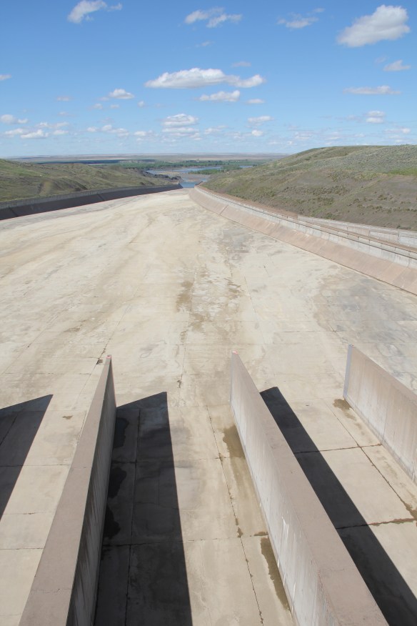
Two weeks of very concentrated fieldwork, touching most of Eastern Montana. Over 4000 miles of territory covered. Many, many places investigated, many questions raised and some questions answered. I am two days removed from the Hi-Line sojourn and over the next weeks I will explored in greater depth the many significant places and stories that Montanans have shared with me. This first image–of the iconic concrete Fort Peck spillway (mid 1930s), located in McCone County–is a teaser. But it speaks of the unexpected monumentality of the landscape, the starkness of the distances, and a theme to which I will return to again, and probably again: Montana reflects a marvelous natural beauty but it also reflects a decades-old attempt by men and women to conquer those resources, distances, and space by means of faith in technology. The spillway is just an overwhelming example–just as important are the irrigation ditches that crisscross the region; the two-lane roads that bisect it; and the bands of steel of the region’s railroad networks. Our search to master the northern plains continues, and the land, it is obvious to me, is up to the challenge.

Sand Springs School, Garfield County

Image

20130602-054917.jpg

One room schools are a huge source of interest among preservationists in the northern plains. Most are gone; some were preserved in building zoos (almost every Montana county museum will have a one-room school moved onto its grounds). Here in Garfield County, one if the state’s most sparsely populated places, is one that still operates. Quite a testament to education in a demanding country.

Erasing the Great Northern Image across the Hi-Line

Image

Erasing the Great Northern Image across the Hi-Line

One of the most surprising–for me, even shocking–patterns in the 21st century Hi-Line landscape is how many railroad depots have disappeared from the small towns. Certainly major towns that provide access to the Amtrak passenger service (Havre, Malta, Glasgow, Shelby) still retain their historic buildings. But most others are gone. Certainly the corridor itself remains and the grain elevators still dominate the scene, reminding everyone of the power of agribusiness today, but the stations that told you here is a Great Northern town are not there. The photo is from Rudyard in Hill County where residents took the station, moved it blocks away to the edge of the village, and use it now as a centerpiece for a community museum. In Kevin, Toole County, the depot was moved off the tracks (only slightly, it is still within view of the corridor) and made a Senior center. These places are now rare reminders of the Great Northern’s imprint on the landscape through the means of their standardized design, painted white, passenger stations.

Phillips County Courthouse

Image

20130525-221217.jpg

Here is another building I mentioned earlier this spring, wondering about what happened in the 25 years since I was last in Malta. The courthouse has not been past over for a new building. It is in good shape but you wish they had not added the vines. If unchecked the vines will soon cover the facade and they will eat away on the brick. The real casualty in Malta is the former Carnegie Library, now abandoned and wilting away. Losing that fine neoclassical building will leave a big hole in the town’s heritage fabric.

Ghost towns on Montana’s Soo Line Corridor

Image

20130524-190859.jpg

I discovered years ago that few Montanans, not to mention Canadians, recognized that the Canada-based Soo Line had extended a spur into northeast Montana in the early 20th century. Some of the towns created in the wake of the railroad remain but most are gone, marked as a spot on the state map but really they are only towns in people’s memories. The state historic preservation office 20 years ago placed Comertown on the National Register. The next town west , Dooley (shown here) is another worthy candidate. In 2005 residents past (and present?) placed a large boulder to mark the town, etching buildings and dates for posterity. Or so they thought. The etchings are already going faint in the harsh wind blown plains. The church remains–but for how much longer?

Listening at Camp Fortunate, 2012

Image

20130515-211917.jpg

So many of the blogs in the last 3 weeks have spoken of looking and seeing change over a generation. But just as important as close viewing is close listening. The voices of Montana sound different from those of my native Tennessean but I often heard similar tales: themes of community, family challenge, opportunities lost and gained, the heavy hand of power be it capital or the federal presence, and the stories of the deeper past, called intangible by some but oh so tangible to those who touch it, feel it daily. The landscape loses meaning without the voices. The voices are lost without the landscape.

Ghosts Towns along the Hi-Line

Image

Ghosts Towns along the Hi-Line

In 1984 I began my statewide fieldwork on the Hi-Line with Toole County being among the first stops. Here I encountered Devon, a town name that denotes rural beauty from Great Britain, but here along the Great Northern Railway and U.S. 2 it had become a forgotten place. I soon discovered that many other Devons existed in the region, and I talked about a good many of them in the “Travelers Companion to Montana History” book. Since that time, Don Baker has written “Ghost Towns of the Montana Prairie” that documents even more of these places. Three decades later, my basic question is: how many of these ghosts have now blown away leaving only scattered foundations behind? Those that remain are powerful physical documents of the Homesteading Era, which 100 years ago still held such hope and promise for the region.

Fort Owen 2012

Image

20130511-134652.jpg

Vast improvement in presentation and interpretation is a very clear trend that I found last year in the southwest corner of Montana. Fort Owen outside of Stevensville was one such place, here under the stewardship of the state. It was good to see improvement over 25 years but at the same time, the story at Fort Owen is BIG and nationally significant, I would claim. And the property today does not do justice to the park. Then there is the danger of development in and around Stevensville completely overwhelming the site. What will be the status of state historic sites and parks in northern Montana?

Then there is the personal side of exploring Montana’s historic landscape. My son Owen is named for this little but important place in a really big country.