
In my 1984-1985 work on the state historic preservation plan, the working assumption was that Madison County was, well, good. Tons of attention since the 1930s had been showered on the mining towns of Virginia City and Nevada City. The former was recognized as a National Historic Landmark; if one back then thought of rural counties where preservation was valued and key resources identified, then Madison County was the place.
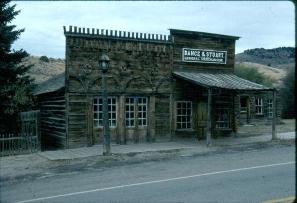
Virginia City, 1984
I came to appreciate that Madison County is much more than ghost towns, and that appreciation has grown in the decades since. It is a rich agricultural landscape, what I like to call a working landscape where ranching still matters, a lot. Here the past blends with the present in interesting and challenging ways, thus several blogs will explore the historical landscapes of Madison County, from the territorial era to today.
 Montana Highway 41 and the western side of the county is where I start, with the town of Silver Star, nestled between a spur line of the Northern Pacific Railroad, Highway 41, and Jefferson River. Gold was discovered nearby in 1866 and the town is named for a mine, but growth came more from transportation, with Silver Star serving as an early transportation stop between Virginia City and Helena in the 1870s. Today the place is best known for a privately held massive collection of mining machines, tools, and artifacts established by Lloyd Harkins, and for its rural post office that is nestled within the town’s general store.


South of Silver Star along MT Highway 41 is frankly a spectacular rural landscape, with the Jefferson River and the Tobacco Root Mountains providing most of the backdrop. The river
 valley and its irrigation systems helped to produce one of the most famous barns in the state: the Round Barn, just north of Twin Bridges. In 1882 Noah Armstrong, who had made a fortune in mining, built the barn as part of his Doncaster Stable and Stud Farm. In 1933
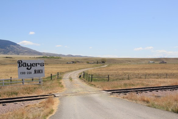 the Bayers family acquired the barn and incorporated it into their cattle business. When I visited in 1912 the barn was still an agricultural structure, with its wedding cake shape casting a distinct profile on the landscape. In 2015, the barn was restored to a new use: as a wedding and event reception space.


This section of Montana 41 also followed a route traveled by the Lewis and Clark expedition in August 1805. Today, like most of the trail throughout the state, there is much more public interpretation than in the 1980s. The marker below on Montana 41 explains the expedition’s confusion over the junction of the Big Hole and Jefferson rivers; in Twin Bridges there is an outdoor interpretive area at the county fairgrounds that commemorates the expedition, especially the role of Sacajawea.


The real jewels at the Madison County Fairgrounds are the historic buildings themselves–a wonderful set of New Deal-era public buildings crafted by the Works Progress Administration in the mid-1930s. An earlier post reviewed the fairgrounds history, noting that “‘WPA engineer C. D. Paxton drew the plans and Tosten Stenberg, well known for his log structures in Yellowstone Park, directed construction. Local foreman Fred Sommers was brought out of retirement with a special waiver from Washington to supervise the project. Lodgepole pine, fir logs, and other building materials were gathered locally and prepared by workers on site.'”

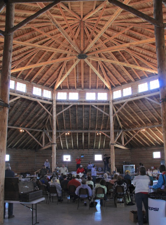 The result is spectacular, and with their restoration in the last 30 years, the buildings are not just landmarks but busy throughout the spring, summer, and fall.


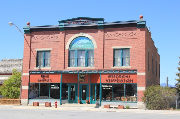
Twin Bridges is also more than the fairgrounds. When I visited for the first time in almost 30 years in 2012, the entire business district has getting an infrastructure facelift. The construction did not diminish my appreciation for the range of historic commercial


buildings along the highway. Most worthy of note is the late Victorian-styled Reid Block of 1917, the construction of which coincided with the homesteading boom in this part of the county. The Reid Block is now home to the Twin Bridges Historical Association.
 The Old Hotel, a brick two-story gable-front building, also marks the town’s ascent during the early 20th century when the town achieved its highest population, about 750 in 1920. Today about half of that number call Twin Bridges home.
 My personal favorite, and a frequent stop during the 1980s, is the Blue Anchor Bar, nestled on the first floor, with an Art Deco style redesign, in a two-story commercial block.
 Twin Bridges is a very important river junction, thus the name, where the Beaverhead, Big Hole, and Ruby rivers all meet to form the Jefferson River. A public park near the confluence just south of the Montana 41/287 helps to tell that story. Nearby is the Twin Bridges School and its amazing modernist styled gymnasium.


Twin Bridges School is award winning and clearly the pride of every resident. Another part of Montana’s history of childhood education is also at Twin Bridges, the Montana State Orphanage later known as the State Home for Children. The Queen Anne-style orphanage

dates to 1894–it was known as “The Castle” and is listed in the National Register– and as the decades passed the state enlarged the facility and added modern-styled facilities to the complex. The state closed the orphanage in 1975. Ever since that time, preservationists statewide and residents locally have tried to come up with an adaptive reuse plan that could put the buildings back in service.


For a brief history of the orphanage, visit the blog post “There’s No Place like Home: The Role of the Montana State Orphanage” on the montanawomenshistory.org blog. It features historic photographs of the orphanage. In 2010 the Bozeman Daily Chronicle featured the deteriorating campus in a news feature, wondering when and if preservation and adaptive reuse would happen. That question remains today.
